 |
To be completed by any available volunteer! |
 |
The coastal lands along the Gulf of Harad are home to the Haradric people known as the Gulfings. This land is shaped and nourished by the Gulf of Harad, named by its inhabitants as Khopazûl, which borders the region to the south and east. The region covers the area south-east of the Great Desert and north-east of the Far Harad Grasslands. This part of Near Harad is still relatively dry, but fertile and home to a flourishing sub-faction of Near Haradrim who are known as the Gulfings.
The surface terrain is a mix of grass, dirt, sand and red sand. The composition of the terrain varies smoothly over scales of a few hundred blocks - so one may find scrubby regions with plenty of sand and dirt, lush green regions with only scattered small patches of sand and dirt, and regions anything in-between.
The Gulfings enjoy a relatively safe geographical situation resulting in only little to no hostilities on their own soil. The population is spread out and inhabits villages and towns. Their allegiance with their Near Haradrim kin and consequently the forces of Mordor, make that they too have a ready-for-combat military presence in the form of a standing army, mustered in military encampments spread thrughout the lands.
The land doesn't receive lots of rainfall but its climate and soils are friendly and nourish plenty of tropical surprises. The region is home to two unique species: the White Oryx antelope and the Dragonblood Tree. The latter dominates the only sub-biome of the region, the Gulf of Harad Forest, which is situated on the eastern peninsula.
Upon entering this region, players unlock the achievement: Eastern Shores.
Sub-biomes
Gulf of Harad Forest
Forested sub-biome of the Gulf of Harad.
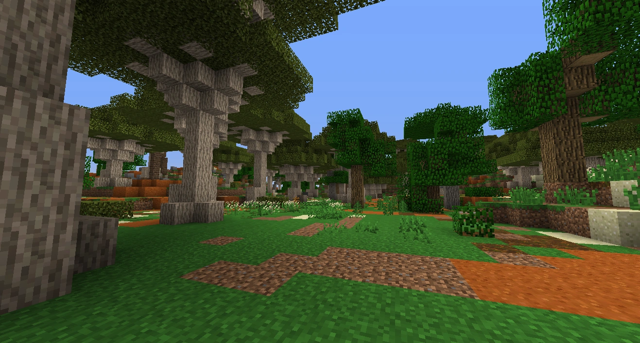
This ancient forest is predominantly a forest of Dragonblood Trees. It is located on the peninsula in the south-east of Near Harad, that penetrates into the eastern seas and forms a barrier between the Gulf of Harad and the vast sea. The peninsula has a local climate that proves optimal for growth of the unique Dragonblood trees, a species that is known to be able to cope with harsh, dry and windy conditions and grow extremely old.
Variants
- Flowers - A version of the biome with an abundance of flowers.
- Forest - A more forested version of the biome.
- Light Forest - A lightly forested version of the biome.
- Steppe - A very flat version of the biome.
- Barren Steppe - A steppe, but with no trees. Structures generate here very commonly.
- Hills - A hillier version of the biome.
- Forest Hills - A forested version of the hill variant.
- Scrubland - Scrublands are typically areas with very poor, sandy and/or rocky soil. This results in very little tree growth and the vegetation is dominated by low growing scrubs (stunted trees / shrubbs) and bushes.
- Sandy Scrublands - A very sandy version of aforementioned scrublands.
- Sandy Scrubland Hills - A hilly version of the Samdy Scrublands..
- Orange Orchard - An orchard containing orange trees.
- Lemon Orchard - An orchard containing lemon trees.
- Lime Orchard - An orchard containing lime trees.
- Olive Orchard - An orchard containing olive trees.
- Almond Orchard - An orchard containing almond trees.
- Plum Orchard - An orchard containing plum trees.
- Date Orchard - An orchard containing date trees.
Structures
The Gulfings inhabit villages and towns. These are comprised of a number of various individual structures all (to be!) listed below:
- Gulfing Settlement - Further detailing and description to be added.
Alongside the Gulfings, also Morwaith mercenaries are mustered for the war in the north, and reside in temporary camps in the area:
- Morwaith Mercenary Camp - small camps where one can hire mercenaries out of the Far Harad.
Finally, there are also the silent witnesses of the past:
- Harad Obelisk - weathered sandstone monuments found across Near Harad.
- Mûmak Skeleton - the old remains of Mumakil who have died, some from natural causes, others from violence.
To be completed.
Mobs
This land is home to the Gulfings of Near Harad.
- Gulfing - Members of a Haradric people who dwell along the Gulf of Harad.
- Gulfing Warrior - The brave warriors of the Khopazûl.
- Gulfing Archer - Bowmen of the Gulfing armies.
- Morwaith Mercenaries - Tribal mercenaries from the wildlands of Far Harad.
To be completed.
Mining
As in the other regions of Near Harad, beneath the Gulf of Harad all the normal ores can be found, as well as Lapis Lazuli.
Vegetation
The Gulf of Harad has all of the flowers that are found exclusively in Harad: Southbells, Sand Gems, Hibiscus, Harad Daisies, and the Flame of Harad. Oak, palm, acacia, date palm, olive, almond, orange, lemon, and lime trees are all present here. In addition, the Dragonblood Tree is exclusive to this biome.
Trivia

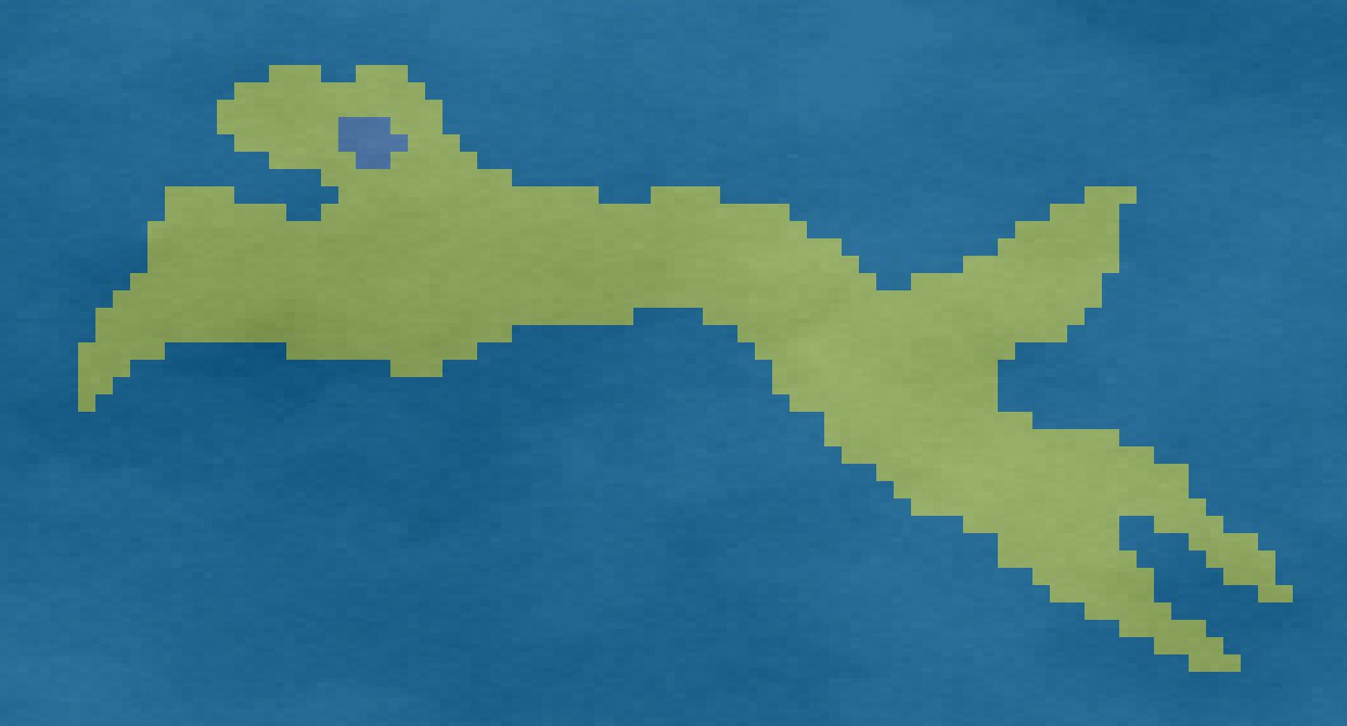
Dog-shaped island in the gulf of Harad
The map of Near Harad underwent a massive transition with Update 34, endangering the famed doggo-shaped biome of Near Harad Fertile. Fans of doggos and in particularly the perceived 'Haradoggo', passionately lead by the inimitable Dragonovith, launched a massive promotional action to persuade the Mod Team to not let Haradoggo go with the introduction of Update 34. This resulted in the Haradoggo-shaped island in the north-east of the Gulf of Harad.
|
Coast •
Desert •
Gulf •
Harnennor •
Lostladen •
Umbar |