(pipe-weed) Tag: B35 |
(renewed tabber) Tag: U36 |
||
| (14 intermediate revisions by 5 users not shown) | |||
| Line 1: | Line 1: | ||
| + | {{Edition}} |
||
| − | + | [[File:ShireWaypoints.png|center|thumb|700px|The predefined waypoints of [[the Shire]].]] |
|
| − | '''Waypoints''' are points on the Middle-earth [[Biomes|biome]] map which form the basis of the [[Fast Travel System|fast travel]]. There are two kinds of waypoints: Custom (displayed in white) and predefined (in |
+ | '''Waypoints''' are points on the Middle-earth [[Biomes|biome]] map which form the basis of the [[Fast Travel System|fast travel]]. There are two kinds of waypoints: Custom (displayed in white) and predefined (in beige). |
==Using the Map== |
==Using the Map== |
||
| Line 10: | Line 11: | ||
[[File:MapButtons1.png|thumb|x112px|left|Toggle display: None - all - predefined - custom.]] |
[[File:MapButtons1.png|thumb|x112px|left|Toggle display: None - all - predefined - custom.]] |
||
| − | To toggle the display of the waypoints on the map, click on the respective button in the top right corner of the map. It cycles through the options none (red "0"), all ( |
+ | To toggle the display of the waypoints on the map, click on the respective button in the top right corner of the map. It cycles through the options none (red "0"), all (beige + white), predefined only (beige) and custom only (white) as shown in the picture to the left. The colours of the waypoints match those of the button. The "none" option also removes the roads from the map. |
{{clr}} |
{{clr}} |
||
==Custom Waypoints== |
==Custom Waypoints== |
||
| − | Custom waypoints - displayed in white - can be created by players. In the beginning, the Mod allows you to set 5 custom [[waypoints]] per world. You can unlock more by earning [[achievements]]. This function is important to reach your buildings immediately as they are normally not right at the predefined fast travel points. |
+ | Custom waypoints - displayed in white - can be created by players. In the beginning, the Mod allows you to set 5 custom [[waypoints]] per world. You can unlock more by earning [[achievements]], which grant 1 extra custom waypoint per 5 Middle-earth achievements. This function is important to reach your buildings immediately as they are normally not right at the predefined fast travel points. |
[[File:CustomWaypointExample.png|thumb|center|500px|A custom waypoint in the Mountains of the Wind.]] |
[[File:CustomWaypointExample.png|thumb|center|500px|A custom waypoint in the Mountains of the Wind.]] |
||
| Line 25: | Line 26: | ||
To delete a custom waypoint, click on it and press the red minus sign which will appear. Confirm that you really want to delete the waypoint. To rename a waypoint, press the button with the three dots. You will be prompted for a new name. Press "enter" to confirm or cancel with "Esc". |
To delete a custom waypoint, click on it and press the red minus sign which will appear. Confirm that you really want to delete the waypoint. To rename a waypoint, press the button with the three dots. You will be prompted for a new name. Press "enter" to confirm or cancel with "Esc". |
||
| − | You can only create a waypoint at your current position. This is to prevent what would essentially be free teleportation to anywhere on the map without actually travelling there first. |
+ | You can only create a waypoint at your current position. This is to prevent what would essentially be free teleportation to anywhere on the map without actually travelling there first. Custom waypoints can't be created in someone else's [[Banners#Banner Protection|banner protected]] area. |
| − | <!-- Not sure, what happens, if |
+ | <!-- Not sure, what happens, if someone protects an area, which contains an already defined waypoint. If you find out, please add it here and remove this comment. - ffets --> |
Please note that these are player-specific, that is to say, custom waypoints you create will not be available (nor visible) to other players on multiplayer - unless you share your custom waypoint with your [[fellowship]]. Press the button with the arrow and then enter the fellowship's name. Other players may go to the same location and create their own custom waypoints there as well to gain access to the same spot. |
Please note that these are player-specific, that is to say, custom waypoints you create will not be available (nor visible) to other players on multiplayer - unless you share your custom waypoint with your [[fellowship]]. Press the button with the arrow and then enter the fellowship's name. Other players may go to the same location and create their own custom waypoints there as well to gain access to the same spot. |
||
==Predefined Waypoints== |
==Predefined Waypoints== |
||
| − | Predefined waypoints (displayed in |
+ | Predefined waypoints (displayed in beige) are placed at a pre-set location, and all those waypoints have a name, of which most are taken from the Middle-earth canon. When you click on a waypoint, some lore related to it will be displayed. |
| − | '''Note''': Major structures (like cities etc.) denoted by the waypoints are presently '''not implemented''' by the Mod. So, you will already find the [[Ring of Isengard]] (big wall) around the Isengard waypoint, but not the Orthanc tower itself. Waypoints denoting mountains will normally have the [[Fixed Mountains and Hills|mountain]] generated nearby. |
+ | '''Note''': Major structures (like cities etc.) denoted by the waypoints are presently '''not implemented''' by the Mod (except for the [[Bree-land Settlement|villages]] of [[Bree-land (Biome)|Bree-land]]). So, you will already find the [[Ring of Isengard]] (big wall) around the Isengard waypoint, but not the Orthanc tower itself. Waypoints denoting mountains will normally have the [[Fixed Mountains and Hills|mountain]] generated nearby. |
[[Road]]s pass through predefined waypoints, and the path the road takes is determined by the position of those waypoints. |
[[Road]]s pass through predefined waypoints, and the path the road takes is determined by the position of those waypoints. |
||
| − | |||
[[File:WaypointExample.png|thumb|center|500px|Waypoints connected by roads.]] |
[[File:WaypointExample.png|thumb|center|500px|Waypoints connected by roads.]] |
||
| + | |||
The total list of waypoints has been split up into different regions/biomes to help the reader not feel overwhelmed. Most of these list follow a pattern (starting here, going right, then down, then left, etc), but some biomes (such as the Shire) have so many waypoints that list has been put into alphabetical order. The regions are also those used in the [[#Commands|command]] below. |
The total list of waypoints has been split up into different regions/biomes to help the reader not feel overwhelmed. Most of these list follow a pattern (starting here, going right, then down, then left, etc), but some biomes (such as the Shire) have so many waypoints that list has been put into alphabetical order. The regions are also those used in the [[#Commands|command]] below. |
||
| Line 44: | Line 45: | ||
'''Game coordinates''' are the position as shown under the compass rose or by the F3-function while actually playing the game. It will be also displayed, when you click a waypoint or hover over the in-game map. |
'''Game coordinates''' are the position as shown under the compass rose or by the F3-function while actually playing the game. It will be also displayed, when you click a waypoint or hover over the in-game map. |
||
| − | The descriptions are mainly taken from the in-game lore, enhanced by some additional info. If you are |
+ | The descriptions are mainly taken from the in-game lore, enhanced by some additional info. If you are interested in more Middle-earth lore, please follow the links, that point to our twin wiki, [[w:c:lotr|The One Wiki to Rule Them All]]. |
If you want to find info on a specific waypoint on this page, it's wise use the search function of your browser, normally Ctrl-F. |
If you want to find info on a specific waypoint on this page, it's wise use the search function of your browser, normally Ctrl-F. |
||
| Line 59: | Line 60: | ||
*[[w:c:lotr:Meneltarma|Meneltarma]] |
*[[w:c:lotr:Meneltarma|Meneltarma]] |
||
| − | ::The position of this secret island is classified information on this wiki. '''Don't add it here.''' |
+ | ::The position of this secret island is classified information on this wiki. '''Don't add it here.''' [[w:c:lotr:Meneltarma|Meneltarma]] can no longer be seen on the map if you have not yet sailed there. |
::The summit of the [[w:c:lotr:Meneltarma|Meneltarma]], the Sacred Mountain, which alone survived the downfall of [[w:c:lotr:Númenor|Númenor]] as an [[w:c:lotr:Category:Islands|island]] in the Third Age. The name means "the Pillar of the Heavens". |
::The summit of the [[w:c:lotr:Meneltarma|Meneltarma]], the Sacred Mountain, which alone survived the downfall of [[w:c:lotr:Númenor|Númenor]] as an [[w:c:lotr:Category:Islands|island]] in the Third Age. The name means "the Pillar of the Heavens". |
||
| − | ===Shire=== |
+ | ===The Shire=== |
*[[w:c:lotr:Brandywine Bridge|Brandywine Bridge]] – {{MapCoords|5568|-576}} |
*[[w:c:lotr:Brandywine Bridge|Brandywine Bridge]] – {{MapCoords|5568|-576}} |
||
::A bridge across the [[w:c:lotr:Brandywine River|River Brandywine]] and out of the [[w:c:lotr:Shire|Shire]]. It is one of only three ways to cross the [[w:c:lotr:Brandywine River|river]] without swimming. The others are the [[w:c:lotr:Bucklebury Ferry|Bucklebury ferry]] and the [[w:c:lotr:Sarn Ford|Sarn Ford]]. |
::A bridge across the [[w:c:lotr:Brandywine River|River Brandywine]] and out of the [[w:c:lotr:Shire|Shire]]. It is one of only three ways to cross the [[w:c:lotr:Brandywine River|river]] without swimming. The others are the [[w:c:lotr:Bucklebury Ferry|Bucklebury ferry]] and the [[w:c:lotr:Sarn Ford|Sarn Ford]]. |
||
| Line 143: | Line 144: | ||
::A strange and haunted valley where the [[w:c:lotr:Withywindle|Withywindle]] runs through the [[w:c:lotr:Old Forest|Old Forest]]. The river is a tributary of the [[w:c:lotr:Brandywine River|Brandywine River]]. [[w:c:lotr:Tom Bombadil|Tom Bombadil]] lives nearby it. |
::A strange and haunted valley where the [[w:c:lotr:Withywindle|Withywindle]] runs through the [[w:c:lotr:Old Forest|Old Forest]]. The river is a tributary of the [[w:c:lotr:Brandywine River|Brandywine River]]. [[w:c:lotr:Tom Bombadil|Tom Bombadil]] lives nearby it. |
||
| − | === |
+ | ===Lindon=== |
*[[w:c:lotr:Forlindon|Forlindon]] - {{MapCoords|-35520|-11712}} |
*[[w:c:lotr:Forlindon|Forlindon]] - {{MapCoords|-35520|-11712}} |
||
::The northern regions of the fair country of [[w:c:lotr:Lindon|Lindon]]. |
::The northern regions of the fair country of [[w:c:lotr:Lindon|Lindon]]. |
||
| Line 168: | Line 169: | ||
::An ancient hill in Lindon, which, long ago in the Elder Days, was a lookout-post of great importance in the southeast of [[w:c:lotr:Forlindon|Forlindon]]. |
::An ancient hill in Lindon, which, long ago in the Elder Days, was a lookout-post of great importance in the southeast of [[w:c:lotr:Forlindon|Forlindon]]. |
||
| − | === |
+ | ===Blue Mountains=== |
*[[w:c:lotr:Belegost|Belegost]] - {{MapCoords|-24000|-16576}} |
*[[w:c:lotr:Belegost|Belegost]] - {{MapCoords|-24000|-16576}} |
||
| − | ::An ancient Dwarven city of the [[w:c:lotr:Blue Mountains|Blue Mountains]], dating back to the Elder Days. It was destroyed after the War of Wrath, but later |
+ | ::An ancient Dwarven city of the [[w:c:lotr:Blue Mountains|Blue Mountains]], dating back to the Elder Days. It was destroyed after the War of Wrath, but later resettled, in part. |
*[[w:c:lotr:Nogrod|Nogrod]] - {{MapCoords|-23488|-11968}} |
*[[w:c:lotr:Nogrod|Nogrod]] - {{MapCoords|-23488|-11968}} |
||
| − | ::An ancient Dwarven city of the [[w:c:lotr:Blue Mountains|Blue Mountains]], dating back to the Elder Days. It was destroyed after the War of Wrath, but later |
+ | ::An ancient Dwarven city of the [[w:c:lotr:Blue Mountains|Blue Mountains]], dating back to the Elder Days. It was destroyed after the War of Wrath, but later resettled, in part. |
*[[w:c:lotr:Thorin II Oakenshield|Thorin's Halls]] - {{MapCoords|-21568|-7488}} |
*[[w:c:lotr:Thorin II Oakenshield|Thorin's Halls]] - {{MapCoords|-21568|-7488}} |
||
| Line 187: | Line 188: | ||
::Abandoned mines in the [[w:c:lotr:Blue Mountains|Blue Mountains]]. The last King of Arnor Arvedui and his company once hid here in his later days to escape the threat of {{Faction|Angmar}}. |
::Abandoned mines in the [[w:c:lotr:Blue Mountains|Blue Mountains]]. The last King of Arnor Arvedui and his company once hid here in his later days to escape the threat of {{Faction|Angmar}}. |
||
| − | *Thráin |
+ | *Thráin's Halls - {{Template:MapCoords|-17984|8128}} |
| − | ::A Dwarven settlement, founded by Thráin and the exiles of the Lonely Mountain, with many old mines still in use. |
+ | ::A Dwarven settlement, founded by Thráin and the exiles of the Lonely Mountain, with many old mines still in use today. |
| − | === |
+ | ===Eriador=== |
*[[w:c:lotr:Annúminas|Annúminas]] - {{MapCoords|576|-8768}} |
*[[w:c:lotr:Annúminas|Annúminas]] - {{MapCoords|576|-8768}} |
||
::The old capital of Arnor, the North-kingdom, before it was abandoned in favour of [[w:c:lotr:Fornost|Fornost Erain]]. It's located north of the [[Shire]]. |
::The old capital of Arnor, the North-kingdom, before it was abandoned in favour of [[w:c:lotr:Fornost|Fornost Erain]]. It's located north of the [[Shire]]. |
||
| Line 212: | Line 213: | ||
::These dark woodlands are among the last remnants of the ancient forest that once covered all [[w:c:lotr:Eriador|Eriador]]. It is a cape in the very south of [[w:c:lotr:Minhiriath|Minhiriath]]. |
::These dark woodlands are among the last remnants of the ancient forest that once covered all [[w:c:lotr:Eriador|Eriador]]. It is a cape in the very south of [[w:c:lotr:Minhiriath|Minhiriath]]. |
||
| ⚫ | |||
| ⚫ | |||
| ⚫ | |||
| ⚫ | |||
| ⚫ | |||
| − | |||
| ⚫ | |||
| ⚫ | |||
| ⚫ | |||
*[[w:c:lotr:Staddle|Staddle]] - {{MapCoords|14528|832}} |
*[[w:c:lotr:Staddle|Staddle]] - {{MapCoords|14528|832}} |
||
| Line 223: | Line 221: | ||
*[[w:c:lotr:Combe|Combe]] - {{MapCoords|15040|192}} |
*[[w:c:lotr:Combe|Combe]] - {{MapCoords|15040|192}} |
||
| − | ::A village of Men on the road to the [[w:c:lotr:Chetwood|Chetwood]] |
+ | ::A village of Men on the road to the [[w:c:lotr:Chetwood|Chetwood]]. |
*[[w:c:lotr:Archet|Archet]] - {{MapCoords|15296|-448}} |
*[[w:c:lotr:Archet|Archet]] - {{MapCoords|15296|-448}} |
||
::A town of the Bree-folk on the edge of the [[w:c:lotr:Chetwood|Chetwood]] with a lively logging trade. |
::A town of the Bree-folk on the edge of the [[w:c:lotr:Chetwood|Chetwood]] with a lively logging trade. |
||
| ⚫ | |||
| ⚫ | |||
| ⚫ | |||
| + | |||
| ⚫ | |||
*[[w:c:lotr:Weathertop|Weathertop]] - {{MapCoords|24128|-832}} |
*[[w:c:lotr:Weathertop|Weathertop]] - {{MapCoords|24128|-832}} |
||
::The ruined watchtower of [[w:c:lotr:Weathertop|Amon Sûl]]. In olden days it housed one of the great Seeing Stones of Arnor. It's southernmost and highest summit of the [[w:c:lotr:Weathertop|Weather Hills]]. |
::The ruined watchtower of [[w:c:lotr:Weathertop|Amon Sûl]]. In olden days it housed one of the great Seeing Stones of Arnor. It's southernmost and highest summit of the [[w:c:lotr:Weathertop|Weather Hills]]. |
||
*[[w:c:lotr:Last Bridge|The Last Bridge]] - {{MapCoords|35648|-1984}} |
*[[w:c:lotr:Last Bridge|The Last Bridge]] - {{MapCoords|35648|-1984}} |
||
| − | ::The last bridge on the [[w:c:lotr:Great East Road|Great East Road]] before the [[w:c:lotr:Misty Mountains|Misty Mountains]]. As the only crossing of the river [[w:c:lotr:Hoarwell|Mitheithel]], the Bridge of Mitheithel was an ancient stone bridge |
+ | ::The last bridge on the [[w:c:lotr:Great East Road|Great East Road]] before the [[w:c:lotr:Misty Mountains|Misty Mountains]]. As the only crossing of the river [[w:c:lotr:Hoarwell|Mitheithel]], the Bridge of Mitheithel was an ancient stone bridge (although it is a wooden bridge in the mod). |
*Old Elven Way - {{MapCoords|27968|15040}} |
*Old Elven Way - {{MapCoords|27968|15040}} |
||
::An old road once travelled by Elves of [[w:c:lotr:Eregion|Eregion]]. It is located in the southern Lone-lands, near [[w:c:lotr:Swanfleet|Swanfleet]]. |
::An old road once travelled by Elves of [[w:c:lotr:Eregion|Eregion]]. It is located in the southern Lone-lands, near [[w:c:lotr:Swanfleet|Swanfleet]]. |
||
| − | === |
+ | ===Rivendell Vale=== |
*[[w:c:lotr:Ford of Bruinen|Ford of Bruinen]] - {{MapCoords|45248|-832}} |
*[[w:c:lotr:Ford of Bruinen|Ford of Bruinen]] - {{MapCoords|45248|-832}} |
||
::The shallow ford crossing the [[w:c:lotr:Bruinen|Loudwater]] into the realm of [[w:c:lotr:Rivendell|Rivendell]], protected by the High Elves. |
::The shallow ford crossing the [[w:c:lotr:Bruinen|Loudwater]] into the realm of [[w:c:lotr:Rivendell|Rivendell]], protected by the High Elves. |
||
| Line 245: | Line 246: | ||
::The hidden valley of [[w:c:lotr:Rivendell|Imladris]], where Lord [[w:c:lotr:Elrond|Elrond]] and Lady [[w:c:lotr:Arwen|Arwen]] dwell with their people in the [[w:c:lotr:Rivendell|Last Homely House East of the Sea]]. |
::The hidden valley of [[w:c:lotr:Rivendell|Imladris]], where Lord [[w:c:lotr:Elrond|Elrond]] and Lady [[w:c:lotr:Arwen|Arwen]] dwell with their people in the [[w:c:lotr:Rivendell|Last Homely House East of the Sea]]. |
||
| − | === |
+ | ===Trollshaws=== |
*[[w:c:lotr:Trollshaws|Trollshaws]] - {{MapCoords|41024|-3392}} |
*[[w:c:lotr:Trollshaws|Trollshaws]] - {{MapCoords|41024|-3392}} |
||
::A wild and outlandish forest, scattered with old castles and ruins of [[w:c:lotr:Rhudaur|Rhudaur]], and dark caves home to [[w:c:lotr:Trolls|Trolls]] from the mountains. |
::A wild and outlandish forest, scattered with old castles and ruins of [[w:c:lotr:Rhudaur|Rhudaur]], and dark caves home to [[w:c:lotr:Trolls|Trolls]] from the mountains. |
||
| − | === |
+ | ===Angmar=== |
*[[w:c:lotr:Carn Dûm|Carn Dûm]] - {{MapCoords|25664|-28992}} |
*[[w:c:lotr:Carn Dûm|Carn Dûm]] - {{MapCoords|25664|-28992}} |
||
::The capital of the old Kingdom of [[w:c:lotr:Angmar|Angmar]]. The old stronghold of the [[w:c:lotr:Witch-king of Angmar|Witch-king]]. |
::The capital of the old Kingdom of [[w:c:lotr:Angmar|Angmar]]. The old stronghold of the [[w:c:lotr:Witch-king of Angmar|Witch-king]]. |
||
| − | === |
+ | ===Eregion=== |
*[[w:c:lotr:Ost-in-Edhil|Ost-in-Edhil]] - {{MapCoords|38720|17984}} |
*[[w:c:lotr:Ost-in-Edhil|Ost-in-Edhil]] - {{MapCoords|38720|17984}} |
||
::The ruined city of the Elves of Eregion. It was ruled by [[w:c:lotr:Celebrimbor|Celebrimbor]]. |
::The ruined city of the Elves of Eregion. It was ruled by [[w:c:lotr:Celebrimbor|Celebrimbor]]. |
||
| Line 260: | Line 261: | ||
::The western gate of [[w:c:lotr:Khazad-dûm|Khazad-dûm]], now called [[w:c:lotr:Moria|Moria]]: of old the great delvings and mansions of the Dwarves of Durin's Folk and a wonder of the Northern world. |
::The western gate of [[w:c:lotr:Khazad-dûm|Khazad-dûm]], now called [[w:c:lotr:Moria|Moria]]: of old the great delvings and mansions of the Dwarves of Durin's Folk and a wonder of the Northern world. |
||
| − | === |
+ | ===Dunland=== |
*[[w:c:lotr:Dunland|Duneard]] - {{MapCoords|33728|27712}} |
*[[w:c:lotr:Dunland|Duneard]] - {{MapCoords|33728|27712}} |
||
| − | ::A northern village of shepherds and hunters in the |
+ | ::A northern village of shepherds and hunters in the northern reaches of [[w:c:lotr:Dunland|Dunland.]] |
| + | |||
*[[w:c:lotr:Dunland|Dwarrowvale]] - {{MapCoords|34624|33344}} |
*[[w:c:lotr:Dunland|Dwarrowvale]] - {{MapCoords|34624|33344}} |
||
| − | ::A Dunlending village |
+ | ::A Dunlending village grown up around the site of an old hamlet, which, it is said, once hosted Thráin and Thorin Oakenshield during their long wanderings in the wild. |
| + | |||
| − | *[[w:c:lotr:Dunland| |
+ | *[[w:c:lotr:Dunland|Firwold]] - {{MapCoords|33344|38080}} |
| − | ::A |
+ | ::A town of middling size in the highs of Dunland, and a stop for many traders and travellers on their journeys through the region. |
*[[w:c:lotr:Fords of Isen|Fords of Isen]] - {{MapCoords|37440|45760}} |
*[[w:c:lotr:Fords of Isen|Fords of Isen]] - {{MapCoords|37440|45760}} |
||
| Line 272: | Line 275: | ||
*[[w:c:lotr:Dunland|Wulfburg]] - {{MapCoords|34240|47168}} |
*[[w:c:lotr:Dunland|Wulfburg]] - {{MapCoords|34240|47168}} |
||
| − | :: |
+ | ::Once the fortress of Freca's son, the self-styled 'King' Wulf, who seized Meduseld for Dunland during the reign of Helm Hammerhand. |
| − | === |
+ | ===Enedwaith=== |
*[[w:c:lotr:Lond Daer|Lond Daer]] - {{MapCoords|7360|35136}} |
*[[w:c:lotr:Lond Daer|Lond Daer]] - {{MapCoords|7360|35136}} |
||
::The ancient ruins of the first [[w:c:lotr:Númenóreans|Númenórean]] haven in Middle-earth. It is located at the mouth of [[w:c:lotr:Greyflood|River Greyflood]] in the south of [[w:c:lotr:Enedwaith|Enedwaith]]. |
::The ancient ruins of the first [[w:c:lotr:Númenóreans|Númenórean]] haven in Middle-earth. It is located at the mouth of [[w:c:lotr:Greyflood|River Greyflood]] in the south of [[w:c:lotr:Enedwaith|Enedwaith]]. |
||
| Line 284: | Line 287: | ||
::Here the River Isen flows into the Sea after its long course through sparsely-inhabited Enedwaith. |
::Here the River Isen flows into the Sea after its long course through sparsely-inhabited Enedwaith. |
||
| − | === |
+ | ===Nan Curunír=== |
*[[w:c:lotr:Isengard|Isengard]] - {{MapCoords|37440|42048}} |
*[[w:c:lotr:Isengard|Isengard]] - {{MapCoords|37440|42048}} |
||
::A great fortified ring of stone within a vale at the very south of [[w:c:lotr:Misty Mountains|Misty Mountains]], wherein stands the tower of [[w:c:lotr:Orthanc|Orthanc]], stronghold of [[w:c:lotr:Saruman|Saruman]]. |
::A great fortified ring of stone within a vale at the very south of [[w:c:lotr:Misty Mountains|Misty Mountains]], wherein stands the tower of [[w:c:lotr:Orthanc|Orthanc]], stronghold of [[w:c:lotr:Saruman|Saruman]]. |
||
| − | === |
+ | ===Forodwaith and Northlands=== |
*[[w:c:lotr:Cape of Forochel|Cape of Forochel]] - {{MapCoords|-3008|-43456}} |
*[[w:c:lotr:Cape of Forochel|Cape of Forochel]] - {{MapCoords|-3008|-43456}} |
||
::The perilous floes of the [[w:c:lotr:Ice-Bay of Forochel|Icebay]], where only the [[w:c:lotr:Lossoth|Snowmen of Forochel]] dare wander. It's located in the west of [[w:c:lotr:Forodwaith|Forodwaith]]. |
::The perilous floes of the [[w:c:lotr:Ice-Bay of Forochel|Icebay]], where only the [[w:c:lotr:Lossoth|Snowmen of Forochel]] dare wander. It's located in the west of [[w:c:lotr:Forodwaith|Forodwaith]]. |
||
| Line 296: | Line 299: | ||
*[[w:c:lotr:Withered Heath|Withered Heath]] - {{MapCoords|80832|-22208}} |
*[[w:c:lotr:Withered Heath|Withered Heath]] - {{MapCoords|80832|-22208}} |
||
| − | ::A scorched valley in the east of the [[w:c:lotr:Grey Mountains|Grey Mountains]] where, it is said, lurk the last of the [[w:c:lotr:Fire-drakes|Fire-drakes |
+ | ::A scorched valley in the east of the [[w:c:lotr:Grey Mountains|Grey Mountains]] where, it is said, lurk the last of the [[w:c:lotr:Fire-drakes|Fire-drakes]]. |
| − | === |
+ | ===Grey Mountains=== |
*[[w:c:lotr:Dáin I|Dáin's Halls]] - {{MapCoords|57920|-22464}} |
*[[w:c:lotr:Dáin I|Dáin's Halls]] - {{MapCoords|57920|-22464}} |
||
::A colony of [[w:c:lotr:Durin's Folk|Durin's Folk]] in the west of [[w:c:lotr:Grey Mountains|Grey Mountains]], abandoned after [[w:c:lotr:Dáin I|Dáin]] was slain by a [[w:c:lotr:Cold-drakes|Cold-drake]]. |
::A colony of [[w:c:lotr:Durin's Folk|Durin's Folk]] in the west of [[w:c:lotr:Grey Mountains|Grey Mountains]], abandoned after [[w:c:lotr:Dáin I|Dáin]] was slain by a [[w:c:lotr:Cold-drakes|Cold-drake]]. |
||
*[[w:c:lotr:Scatha|Scatha's Lair]] - {{MapCoords|67264|-21440}} |
*[[w:c:lotr:Scatha|Scatha's Lair]] - {{MapCoords|67264|-21440}} |
||
| − | ::Once the lair of [[w:c:lotr:Scatha|Scatha]], a great [[w:c:lotr:Long-worms|Long-worm]], before he was slain by [[w:c:lotr:Fram|Fram]] of the [[w:c:lotr:Éothéod|Éothéod]]. Scatha |
+ | ::Once the lair of [[w:c:lotr:Scatha|Scatha]], a great [[w:c:lotr:Long-worms|Long-worm]], before he was slain by [[w:c:lotr:Fram|Fram]] of the [[w:c:lotr:Éothéod|Éothéod]]. Scatha ruled the [[w:c:lotr:Grey Mountains|Grey Mountains]] long ago. |
| − | === |
+ | ===Misty Mountains=== |
*[[w:c:lotr:Mount Gram|Mount Gram]] - {{MapCoords|37952|-17984}} |
*[[w:c:lotr:Mount Gram|Mount Gram]] - {{MapCoords|37952|-17984}} |
||
::A mountain inhabited by Orcs who often trouble the lands of [[w:c:lotr:Eriador|Eriador]] in the north west of the [[w:c:lotr:Misty Mountains|Misty Mountains]]. |
::A mountain inhabited by Orcs who often trouble the lands of [[w:c:lotr:Eriador|Eriador]] in the north west of the [[w:c:lotr:Misty Mountains|Misty Mountains]]. |
||
| Line 331: | Line 334: | ||
*[[w:c:lotr:Methedras|Mount Methedras]] - {{MapCoords|38592|38592}} |
*[[w:c:lotr:Methedras|Mount Methedras]] - {{MapCoords|38592|38592}} |
||
| − | ::The [[w:c:lotr:Methedras|Last Peak]], |
+ | ::The [[w:c:lotr:Methedras|Last Peak]], southernmost of the [[w:c:lotr:Misty Mountains|Misty Mountains]], whence flow the rivers [[w:c:lotr:Isen|Isen]] and [[w:c:lotr:Entwash|Entwash]]. |
| − | === |
+ | ===Vales of Anduin=== |
*[[w:c:lotr:Framsburg|Framsburg]] - {{MapCoords|56512|-17856}} |
*[[w:c:lotr:Framsburg|Framsburg]] - {{MapCoords|56512|-17856}} |
||
::The ruined city of the [[w:c:lotr:Éothéod|Éothéod]], [[w:c:lotr:Northmen|Northmen]] ancestors of the [[w:c:lotr:Rohirrim|Rohirrim]]. |
::The ruined city of the [[w:c:lotr:Éothéod|Éothéod]], [[w:c:lotr:Northmen|Northmen]] ancestors of the [[w:c:lotr:Rohirrim|Rohirrim]]. |
||
| Line 371: | Line 374: | ||
::The underground halls of [[w:c:lotr:Thranduil|Thranduil]] the [[w:c:lotr:Wood-elves|Elvenking]] in northern [[w:c:lotr:Mirkwood|Mirkwood]]. It is said that they recall the glory of [[w:c:lotr:Menegroth|Menegroth]] in days of old. |
::The underground halls of [[w:c:lotr:Thranduil|Thranduil]] the [[w:c:lotr:Wood-elves|Elvenking]] in northern [[w:c:lotr:Mirkwood|Mirkwood]]. It is said that they recall the glory of [[w:c:lotr:Menegroth|Menegroth]] in days of old. |
||
| − | === |
+ | ===Mirkwood=== |
*[[w:c:lotr:Enchanted river|Enchanted River]] - {{MapCoords|75072|-10176}} |
*[[w:c:lotr:Enchanted river|Enchanted River]] - {{MapCoords|75072|-10176}} |
||
::Here the Elf-path crosses over a gloomy black river that flows from the [[w:c:lotr:Mountains of Mirkwood|Mountains of Mirkwood]] into the forest. It is advised to avoid these waters, for whoever touches them shall not awake... |
::Here the Elf-path crosses over a gloomy black river that flows from the [[w:c:lotr:Mountains of Mirkwood|Mountains of Mirkwood]] into the forest. It is advised to avoid these waters, for whoever touches them shall not awake... |
||
| Line 384: | Line 387: | ||
::Fortress-lair of the [[w:c:lotr:Sauron|Necromancer]] before he fled eastwards, now inhabited by [[w:c:lotr:Khamûl|Khamûl the Easterling]] and his fell servants. |
::Fortress-lair of the [[w:c:lotr:Sauron|Necromancer]] before he fled eastwards, now inhabited by [[w:c:lotr:Khamûl|Khamûl the Easterling]] and his fell servants. |
||
| − | === |
+ | ===Wilderland=== |
*[[w:c:lotr:River Running|River Gate]] - {{MapCoords|85056|-4288}} |
*[[w:c:lotr:River Running|River Gate]] - {{MapCoords|85056|-4288}} |
||
| − | ::An outpost of the [[w:c:lotr:Wood-elves|Wood-elves]] |
+ | ::An outpost of the [[w:c:lotr:Wood-elves|Wood-elves]] at the end of the [[w:c:lotr:Old Forest Road|Old Forest Road]], where it meets the [[w:c:lotr:River Running|River Running]]. |
*[[w:c:lotr:East Bight|East Bight]] - {{MapCoords|80320|12096}} |
*[[w:c:lotr:East Bight|East Bight]] - {{MapCoords|80320|12096}} |
||
| Line 397: | Line 400: | ||
::A crossing in the great roads of [[w:c:lotr:Dale|Dale]] and [[w:c:lotr:Dorwinion|Dorwinion]]. |
::A crossing in the great roads of [[w:c:lotr:Dale|Dale]] and [[w:c:lotr:Dorwinion|Dorwinion]]. |
||
| − | === |
+ | ===Dale=== |
*[[w:c:lotr:Lonely Mountain|Erebor]] - {{MapCoords|83648|-15424}} |
*[[w:c:lotr:Lonely Mountain|Erebor]] - {{MapCoords|83648|-15424}} |
||
::The [[w:c:lotr:Lonely Mountain|Lonely Mountain]]. Herein lies the [[w:c:lotr:King under the Mountain|Kingdom under the Mountain]], a realm of [[w:c:lotr:Durin's Folk|Durin's Folk]]. |
::The [[w:c:lotr:Lonely Mountain|Lonely Mountain]]. Herein lies the [[w:c:lotr:King under the Mountain|Kingdom under the Mountain]], a realm of [[w:c:lotr:Durin's Folk|Durin's Folk]]. |
||
| Line 419: | Line 422: | ||
::The southern port of the [[w:c:lotr:King of Dale|Kingdom of Dale]], and an important point on the trade routes of [[w:c:lotr:Dorwinion|Dorwinion]]. |
::The southern port of the [[w:c:lotr:King of Dale|Kingdom of Dale]], and an important point on the trade routes of [[w:c:lotr:Dorwinion|Dorwinion]]. |
||
| − | === |
+ | ===Iron Hills=== |
*[[w:c:lotr:Iron Hills|West Peak]] - {{MapCoords|99648|-15552}} |
*[[w:c:lotr:Iron Hills|West Peak]] - {{MapCoords|99648|-15552}} |
||
::The nearer of two large peaks in the [[w:c:lotr:Iron Hills|Iron Hills]]. Beneath are the halls of [[w:c:lotr:Dáin II Ironfoot|Dáin Ironfoot]]. |
::The nearer of two large peaks in the [[w:c:lotr:Iron Hills|Iron Hills]]. Beneath are the halls of [[w:c:lotr:Dáin II Ironfoot|Dáin Ironfoot]]. |
||
| Line 426: | Line 429: | ||
::A large mountain in the far eastern end of the [[w:c:lotr:Iron Hills|Iron Hills]]. |
::A large mountain in the far eastern end of the [[w:c:lotr:Iron Hills|Iron Hills]]. |
||
| − | === |
+ | ===Lothlórien=== |
*[[w:c:lotr:Nimrodel|House of Nimrodel]] - {{MapCoords|49728|21056}} |
*[[w:c:lotr:Nimrodel|House of Nimrodel]] - {{MapCoords|49728|21056}} |
||
| − | ::The former home of an |
+ | ::The former home of an Elf-maiden, [[w:c:lotr:Nimrodel|Nimrodel]], who disappeared grieving after her beloved [[w:c:lotr:Amroth|Amroth]] was drowned in the [[w:c:lotr:Belegaer|Sundering Seas]]. |
*[[w:c:lotr:Cerin Amroth|Cerin Amroth]] - {{MapCoords|53824|21440}} |
*[[w:c:lotr:Cerin Amroth|Cerin Amroth]] - {{MapCoords|53824|21440}} |
||
| Line 436: | Line 439: | ||
::The city of the [[w:c:lotr:Galadhrim|Galadhrim]] in [[w:c:lotr:Lothlórien|Lothlórien]], and the heart of [[w:c:lotr:Elves|Elvendom]] on earth, where all the homes are built in trees. |
::The city of the [[w:c:lotr:Galadhrim|Galadhrim]] in [[w:c:lotr:Lothlórien|Lothlórien]], and the heart of [[w:c:lotr:Elves|Elvendom]] on earth, where all the homes are built in trees. |
||
| − | === |
+ | ===Fangorn=== |
*[[w:c:lotr:Wellinghall|Wellinghall]] - {{MapCoords|43968|36416}} |
*[[w:c:lotr:Wellinghall|Wellinghall]] - {{MapCoords|43968|36416}} |
||
::One of [[w:c:lotr:Treebeard|Treebeard's]] [[w:c:lotr:Ent|Ent-houses]] nestled among the spurs of [[w:c:lotr:Methedras|Mount Methedras]]. |
::One of [[w:c:lotr:Treebeard|Treebeard's]] [[w:c:lotr:Ent|Ent-houses]] nestled among the spurs of [[w:c:lotr:Methedras|Mount Methedras]]. |
||
| Line 446: | Line 449: | ||
::A rocky shelf, standing above the trees of [[w:c:lotr:Fangorn Forest|Fangorn Forest]], where one can contemplate the sunlight on the leaves and the wind among their branches. |
::A rocky shelf, standing above the trees of [[w:c:lotr:Fangorn Forest|Fangorn Forest]], where one can contemplate the sunlight on the leaves and the wind among their branches. |
||
| − | === |
+ | ===Rohan=== |
| − | *[ |
+ | *[[Uruk Highlands]] - {{MapCoords|41152|41920}} |
::These lands in the foothills of the [[w:c:lotr:Misty Mountains|Misty Mountains]] once belonged to [[w:c:lotr:Rohan|Rohan]], but are now desolate and burnt by the servants of the [[w:c:lotr:The Hand of Saruman|White Hand]]. |
::These lands in the foothills of the [[w:c:lotr:Misty Mountains|Misty Mountains]] once belonged to [[w:c:lotr:Rohan|Rohan]], but are now desolate and burnt by the servants of the [[w:c:lotr:The Hand of Saruman|White Hand]]. |
||
| Line 483: | Line 486: | ||
::The old fort raised by the heedless Lord Freca, who ruled the lands around the River Adorn, and was said to be part-Dunlending. |
::The old fort raised by the heedless Lord Freca, who ruled the lands around the River Adorn, and was said to be part-Dunlending. |
||
| − | === |
+ | ===White Mountains=== |
*[[w:c:lotr:Andrast|Ras Morthil]] - {{MapCoords|4544|77120}} |
*[[w:c:lotr:Andrast|Ras Morthil]] - {{MapCoords|4544|77120}} |
||
::The last peak at the headland in the very west of the [[w:c:lotr:White Mountains|White Mountains]]. The Men of [[w:c:lotr:Anfalas|Anfalas]] say that wild [[w:c:lotr:Púkel-men|Púkel-men]] still linger in these lands. |
::The last peak at the headland in the very west of the [[w:c:lotr:White Mountains|White Mountains]]. The Men of [[w:c:lotr:Anfalas|Anfalas]] say that wild [[w:c:lotr:Púkel-men|Púkel-men]] still linger in these lands. |
||
| Line 490: | Line 493: | ||
::A refuge of the [[w:c:lotr:Rohirrim|Rohirrim]] beneath the [[w:c:lotr:Dwimorberg|Dwimorberg]], the [[w:c:lotr:Dwimorberg|Haunted Mountain]]. It is said that none living may pass the [[w:c:lotr:Paths of the Dead|Paths of the Dead]]. |
::A refuge of the [[w:c:lotr:Rohirrim|Rohirrim]] beneath the [[w:c:lotr:Dwimorberg|Dwimorberg]], the [[w:c:lotr:Dwimorberg|Haunted Mountain]]. It is said that none living may pass the [[w:c:lotr:Paths of the Dead|Paths of the Dead]]. |
||
| − | * |
+ | *{{TolkienGatewayLink|Tarlang's_Neck|Tarlang's Neck}} - {{MapCoords|50624|61888}} |
::Men say that a [http://tolkiengateway.net/wiki/Tarlang giant] fell here and broke his neck, forming the mountain pass between the [[w:c:lotr:Blackroot Vale|Blackroot Vale]] and [[w:c:lotr:Lamedon|Lamedon]]. |
::Men say that a [http://tolkiengateway.net/wiki/Tarlang giant] fell here and broke his neck, forming the mountain pass between the [[w:c:lotr:Blackroot Vale|Blackroot Vale]] and [[w:c:lotr:Lamedon|Lamedon]]. |
||
| − | === |
+ | ===Gondor=== |
*[[w:c:lotr:Amon Anwar|Halifirien]] - {{MapCoords|63936|60864}} |
*[[w:c:lotr:Amon Anwar|Halifirien]] - {{MapCoords|63936|60864}} |
||
::The [[w:c:lotr:Amon Anwar|Holy Mountain]], westernmost of the [[w:c:lotr:Warning beacons of Gondor|beacon-hills]] of [[w:c:lotr:Gondor|Gondor]]. [[w:c:lotr:Elendil|Elendil]] was once entombed here, and [[w:c:lotr:Cirion|Cirion]] and [[w:c:lotr:Eorl the Young|Eorl]] swore their [[w:c:lotr:Oath of Eorl|Oath]] upon its slopes. |
::The [[w:c:lotr:Amon Anwar|Holy Mountain]], westernmost of the [[w:c:lotr:Warning beacons of Gondor|beacon-hills]] of [[w:c:lotr:Gondor|Gondor]]. [[w:c:lotr:Elendil|Elendil]] was once entombed here, and [[w:c:lotr:Cirion|Cirion]] and [[w:c:lotr:Eorl the Young|Eorl]] swore their [[w:c:lotr:Oath of Eorl|Oath]] upon its slopes. |
||
| Line 524: | Line 527: | ||
::The great [[w:c:lotr:Minas Tirith|Tower of Guard]], capital city of the kingdom of [[w:c:lotr:Gondor|Gondor]], built of seven levels of pure white stone with the [[w:c:lotr:White Tower of Ecthelion|white Tower of Ecthelion]] at its summit. |
::The great [[w:c:lotr:Minas Tirith|Tower of Guard]], capital city of the kingdom of [[w:c:lotr:Gondor|Gondor]], built of seven levels of pure white stone with the [[w:c:lotr:White Tower of Ecthelion|white Tower of Ecthelion]] at its summit. |
||
| − | === |
+ | ===Ithilien=== |
*[[w:c:lotr:Ithilien (Gondor)|North Ithilien]] - {{MapCoords|81600|53952}} |
*[[w:c:lotr:Ithilien (Gondor)|North Ithilien]] - {{MapCoords|81600|53952}} |
||
::The northern reaches of the [[w:c:lotr:Ithilien (Gondor)|Land of the Moon]]. |
::The northern reaches of the [[w:c:lotr:Ithilien (Gondor)|Land of the Moon]]. |
||
| Line 540: | Line 543: | ||
::In better days these hills in southern [[w:c:lotr:Ithilien (Gondor)|Ithilien]] were the residence of some noble and wealthy [[w:c:lotr:Men of Gondor|Gondorian]] families, including the [[w:c:lotr:Stewards of Gondor|House of the Stewards]]. |
::In better days these hills in southern [[w:c:lotr:Ithilien (Gondor)|Ithilien]] were the residence of some noble and wealthy [[w:c:lotr:Men of Gondor|Gondorian]] families, including the [[w:c:lotr:Stewards of Gondor|House of the Stewards]]. |
||
| ⚫ | |||
| ⚫ | |||
| ⚫ | |||
| + | |||
| ⚫ | |||
*[[w:c:lotr:Erui|Crossing of Erui]] - {{MapCoords|77120|69440}} |
*[[w:c:lotr:Erui|Crossing of Erui]] - {{MapCoords|77120|69440}} |
||
::The fords of the [[w:c:lotr:Erui|River Erui]] in [[w:c:lotr:Lossarnach|Lossarnach]]. Many [[w:c:lotr:Men of Gondor|Gondorians]] once perished here in the [[w:c:lotr:Kin-strife|Kin-strife]]. |
::The fords of the [[w:c:lotr:Erui|River Erui]] in [[w:c:lotr:Lossarnach|Lossarnach]]. Many [[w:c:lotr:Men of Gondor|Gondorians]] once perished here in the [[w:c:lotr:Kin-strife|Kin-strife]]. |
||
| Line 547: | Line 553: | ||
::The sweet [[w:c:lotr:Imloth Melui|Valley of Roses]] within [[w:c:lotr:Lossarnach|Lossarnach]]. |
::The sweet [[w:c:lotr:Imloth Melui|Valley of Roses]] within [[w:c:lotr:Lossarnach|Lossarnach]]. |
||
| − | === |
+ | ===Lebennin=== |
*[[w:c:lotr:Pelargir|Pelargir]] - {{MapCoords|74304|79168}} |
*[[w:c:lotr:Pelargir|Pelargir]] - {{MapCoords|74304|79168}} |
||
::The great royal havens of the [[w:c:lotr:Ship-king|Ship-kings]]: The chief harbour of [[w:c:lotr:Gondor|Gondor]] on the banks of the river [[w:c:lotr:Anduin|Anduin]]. |
::The great royal havens of the [[w:c:lotr:Ship-king|Ship-kings]]: The chief harbour of [[w:c:lotr:Gondor|Gondor]] on the banks of the river [[w:c:lotr:Anduin|Anduin]]. |
||
| Line 557: | Line 563: | ||
::The Mouths of [[w:c:lotr:Anduin|Anduin]], home to poor fisher-folk of [[w:c:lotr:Gondor|Gondor]]. |
::The Mouths of [[w:c:lotr:Anduin|Anduin]], home to poor fisher-folk of [[w:c:lotr:Gondor|Gondor]]. |
||
| − | === |
+ | ===Lamedon=== |
*[[w:c:lotr:Ethring|Ethring]] - {{MapCoords|57152|67776}} |
*[[w:c:lotr:Ethring|Ethring]] - {{MapCoords|57152|67776}} |
||
::A long bridge in the [[w:c:lotr:Ringló Vale|Ringló Vale]] on the road from [[w:c:lotr:Pelargir|Pelargir]] to [[w:c:lotr:Erech|Erech]] in southern [[w:c:lotr:Gondor|Gondor]]. |
::A long bridge in the [[w:c:lotr:Ringló Vale|Ringló Vale]] on the road from [[w:c:lotr:Pelargir|Pelargir]] to [[w:c:lotr:Erech|Erech]] in southern [[w:c:lotr:Gondor|Gondor]]. |
||
| Line 564: | Line 570: | ||
::A capital of the province [[w:c:lotr:Lamedon|Lamedon]] near the fords of the [[w:c:lotr:Ciril|River Ciril]], with few inhabitants. |
::A capital of the province [[w:c:lotr:Lamedon|Lamedon]] near the fords of the [[w:c:lotr:Ciril|River Ciril]], with few inhabitants. |
||
| − | === |
+ | ===Blackroot Vale=== |
*[[w:c:lotr:Erech|Erech]] - {{MapCoords|48192|60864}} |
*[[w:c:lotr:Erech|Erech]] - {{MapCoords|48192|60864}} |
||
::A great steep hill, believed to be haunted, and known for the mysterious [[w:c:lotr:Stone of Erech|black stone]] which stands upon the summit. |
::A great steep hill, believed to be haunted, and known for the mysterious [[w:c:lotr:Stone of Erech|black stone]] which stands upon the summit. |
||
| − | === |
+ | ===Pinnath Gelin=== |
*[[w:c:lotr:Pinnath Gelin|Pinnath Gelin]] - {{MapCoords|30144|69568}} |
*[[w:c:lotr:Pinnath Gelin|Pinnath Gelin]] - {{MapCoords|30144|69568}} |
||
::The beautiful [[w:c:lotr:Pinnath Gelin|Green Hills]] in western [[w:c:lotr:Gondor|Gondor]]. |
::The beautiful [[w:c:lotr:Pinnath Gelin|Green Hills]] in western [[w:c:lotr:Gondor|Gondor]]. |
||
| − | === |
+ | ===Dor-en-Ernil=== |
*[[w:c:lotr:Hills of Tarnost|Tarnost]] - {{MapCoords|55232|73024}} |
*[[w:c:lotr:Hills of Tarnost|Tarnost]] - {{MapCoords|55232|73024}} |
||
::A city in [[w:c:lotr:Gondor|Gondor]] built in ancient days by [[w:c:lotr:Elves|Elves]] who have long since sailed [[w:c:lotr:Undying Lands|West]]. |
::A city in [[w:c:lotr:Gondor|Gondor]] built in ancient days by [[w:c:lotr:Elves|Elves]] who have long since sailed [[w:c:lotr:Undying Lands|West]]. |
||
| Line 582: | Line 588: | ||
::A mighty castle and city upon the shores of [[w:c:lotr:Belfalas|Belfalas]], ruled by the [[w:c:lotr:Princes of Dol Amroth|Prince of Dol Amroth]], a subject of [[w:c:lotr:Gondor|Gondor]]. |
::A mighty castle and city upon the shores of [[w:c:lotr:Belfalas|Belfalas]], ruled by the [[w:c:lotr:Princes of Dol Amroth|Prince of Dol Amroth]], a subject of [[w:c:lotr:Gondor|Gondor]]. |
||
| − | === |
+ | ===Tolfalas=== |
*[[w:c:lotr:Tolfalas|Tolfalas]] - {{MapCoords|55104|87616}} |
*[[w:c:lotr:Tolfalas|Tolfalas]] - {{MapCoords|55104|87616}} |
||
::A bleak abandoned isle in the Bay of [[w:c:lotr:Belfalas|Belfalas]] off the coast of [[w:c:lotr:Gondor|Gondor]]. |
::A bleak abandoned isle in the Bay of [[w:c:lotr:Belfalas|Belfalas]] off the coast of [[w:c:lotr:Gondor|Gondor]]. |
||
| − | === |
+ | ===Emyn Muil=== |
*[[w:c:lotr:Amon Hen|Amon Hen]] - {{MapCoords|67264|51392}} |
*[[w:c:lotr:Amon Hen|Amon Hen]] - {{MapCoords|67264|51392}} |
||
::The [[w:c:lotr:Amon Hen|Hill of Sight]], an ancient seat of [[w:c:lotr:Gondor|Gondorian]] power, located near [[w:c:lotr:Falls of Rauros|Rauros]]. |
::The [[w:c:lotr:Amon Hen|Hill of Sight]], an ancient seat of [[w:c:lotr:Gondor|Gondorian]] power, located near [[w:c:lotr:Falls of Rauros|Rauros]]. |
||
| Line 603: | Line 609: | ||
::The southern of two westward bends in the [[w:c:lotr:Anduin|Great River Anduin]]. The shallow fords of the [[w:c:lotr:Undeeps|Undeeps]] were often used by armies as a crossing-point. |
::The southern of two westward bends in the [[w:c:lotr:Anduin|Great River Anduin]]. The shallow fords of the [[w:c:lotr:Undeeps|Undeeps]] were often used by armies as a crossing-point. |
||
| − | === |
+ | ===Dagorlad=== |
*[[w:c:lotr:Black Gate|Black Gate]] - {{MapCoords|84544|51392}} |
*[[w:c:lotr:Black Gate|Black Gate]] - {{MapCoords|84544|51392}} |
||
::The great gates of [[w:c:lotr:Mordor|Mordor]], wrought of twisted steel and dark stone. None pass unless the [[w:c:lotr:Eye of Sauron|Eye]] of the [[w:c:lotr:Barad-dûr|Dark Tower]] wills it. |
::The great gates of [[w:c:lotr:Mordor|Mordor]], wrought of twisted steel and dark stone. None pass unless the [[w:c:lotr:Eye of Sauron|Eye]] of the [[w:c:lotr:Barad-dûr|Dark Tower]] wills it. |
||
| − | === |
+ | ===Mordor=== |
*[[w:c:lotr:Udûn (Mordor)|Valley of Udûn]] - {{MapCoords|84544|53184}} |
*[[w:c:lotr:Udûn (Mordor)|Valley of Udûn]] - {{MapCoords|84544|53184}} |
||
::The [[w:c:lotr:Orc|Orc]]-infested vale between the [[w:c:lotr:Black Gate|Black Gate]] and the [[w:c:lotr:Isenmouthe|Isenmouthe]]. Named in imitation of [[w:c:lotr:Utumno|Udûn]], the first fortress of [[w:c:lotr:Melkor|Morgoth]], also called [[w:c:lotr:Utumno|Utumno]]. |
::The [[w:c:lotr:Orc|Orc]]-infested vale between the [[w:c:lotr:Black Gate|Black Gate]] and the [[w:c:lotr:Isenmouthe|Isenmouthe]]. Named in imitation of [[w:c:lotr:Utumno|Udûn]], the first fortress of [[w:c:lotr:Melkor|Morgoth]], also called [[w:c:lotr:Utumno|Utumno]]. |
||
| Line 629: | Line 635: | ||
::Once [[w:c:lotr:Minas Morgul|Minas Ithil]], the fair Tower of the Moon; now a dark and sickly place ruled by the [[w:c:lotr:Witch-king of Angmar|Lord of the Nazgûl]]. |
::Once [[w:c:lotr:Minas Morgul|Minas Ithil]], the fair Tower of the Moon; now a dark and sickly place ruled by the [[w:c:lotr:Witch-king of Angmar|Lord of the Nazgûl]]. |
||
| − | *[[w:c:lotr:Maegond Spur| |
+ | *[[w:c:lotr:Maegond Spur|Mornost]] - {{MapCoords|95808|71232}} |
::A watch-post upon the [[w:c:lotr:Maegond Spur|shadowy spurs]] of the [[w:c:lotr:Ephel Dúath|Ephel Dúath]] which, along with [[w:c:lotr:Nargroth|Nargroth]] eastward, watched the way into [[w:c:lotr:Núrn|Núrn]]. |
::A watch-post upon the [[w:c:lotr:Maegond Spur|shadowy spurs]] of the [[w:c:lotr:Ephel Dúath|Ephel Dúath]] which, along with [[w:c:lotr:Nargroth|Nargroth]] eastward, watched the way into [[w:c:lotr:Núrn|Núrn]]. |
||
| − | *[[w:c:lotr:Nargroth| |
+ | *[[w:c:lotr:Nargroth|Narroth]] - {{MapCoords|106304|66368}} |
::The [[w:c:lotr:Nargroth|Halls of Fire]], a watchtower above the pass into the plateau of [[w:c:lotr:Gorgoroth|Gorgoroth]],that, along with [[w:c:lotr:Maegond Spur|Morigost]], watches the way into [[w:c:lotr:Núrn|Núrn]]. |
::The [[w:c:lotr:Nargroth|Halls of Fire]], a watchtower above the pass into the plateau of [[w:c:lotr:Gorgoroth|Gorgoroth]],that, along with [[w:c:lotr:Maegond Spur|Morigost]], watches the way into [[w:c:lotr:Núrn|Núrn]]. |
||
| Line 647: | Line 653: | ||
::A fortress that keeps watch over the road into [[w:c:lotr:Mordor|Mordor]] out of [[w:c:lotr:Rhûn|Rhûn]]. |
::A fortress that keeps watch over the road into [[w:c:lotr:Mordor|Mordor]] out of [[w:c:lotr:Rhûn|Rhûn]]. |
||
| − | === |
+ | ===Nan Ungol=== |
*[[w:c:lotr:Nan Ungol|Valley of Spiders]] - {{MapCoords|89920|85824}} |
*[[w:c:lotr:Nan Ungol|Valley of Spiders]] - {{MapCoords|89920|85824}} |
||
::[[w:c:lotr:Nan Ungol|Nan Ungol]], a grim and shadowy corner of [[w:c:lotr:Mordor|Mordor]] in the southwest, infested with the spawn of [[w:c:lotr:Ungoliant|Ungoliant]]. |
::[[w:c:lotr:Nan Ungol|Nan Ungol]], a grim and shadowy corner of [[w:c:lotr:Mordor|Mordor]] in the southwest, infested with the spawn of [[w:c:lotr:Ungoliant|Ungoliant]]. |
||
| − | === |
+ | ===Nurn=== |
| − | *[[w:c:lotr:Thaurband| |
+ | *[[w:c:lotr:Thaurband|Thorband]] - {{MapCoords|106688|79936}} |
| − | ::A terrible prison-fortress of [[w:c:lotr:Mordor|Mordor]] and port upon the shores of [[w:c:lotr:Sea of Núrnen|Núrnen]]. The base of operations for all [[w:c:lotr:Núrn| |
+ | ::A terrible prison-fortress of [[w:c:lotr:Mordor|Mordor]] and port upon the shores of [[w:c:lotr:Sea of Núrnen|Núrnen]]. The base of operations for all [[w:c:lotr:Núrn|Nurn]], [[w:c:lotr:Thaurband|Thorband]] held food for transporting, slaves for processing, and prisons for torturing. |
| − | *[[w:c:lotr:Sea of Núrnen| |
+ | *[[w:c:lotr:Sea of Núrnen|Dunurnen]] - {{MapCoords|107584|81088}} |
::The sad western shores of the [[w:c:lotr:Sea of Núrnen|Sea of Núrnen]]. |
::The sad western shores of the [[w:c:lotr:Sea of Núrnen|Sea of Núrnen]]. |
||
| − | *[[w:c:lotr:Sea of Núrnen| |
+ | *[[w:c:lotr:Sea of Núrnen|Fornurnen]] - {{MapCoords|113472|76096}} |
::The dreary northern shores of the [[w:c:lotr:Sea of Núrnen|Sea of Núrnen]]. |
::The dreary northern shores of the [[w:c:lotr:Sea of Núrnen|Sea of Núrnen]]. |
||
| − | *[[w:c:lotr:Sea of Núrnen| |
+ | *[[w:c:lotr:Sea of Núrnen|Harnurnen]] - {{MapCoords|116288|81856}} |
::The bleak southern shores of the [[w:c:lotr:Sea of Núrnen|Sea of Núrnen]]. |
::The bleak southern shores of the [[w:c:lotr:Sea of Núrnen|Sea of Núrnen]]. |
||
| − | *[[w:c:lotr:Sea of Núrnen| |
+ | *[[w:c:lotr:Sea of Núrnen|Rhunurnen]] - {{MapCoords|121408|75072}} |
::The dim eastern shores of the [[w:c:lotr:Sea of Núrnen|Sea of Núrnen]]. |
::The dim eastern shores of the [[w:c:lotr:Sea of Núrnen|Sea of Núrnen]]. |
||
| − | === |
+ | ===Dorwinion=== |
| − | *[[w:c:lotr:Dorwinion| |
+ | *[[w:c:lotr:Dorwinion|Mirulond]] - {{MapCoords|124736|17088}} |
::The Wine-havens upon the [[w:c:lotr:River Running|Celduin]], where the [[w:c:lotr:Avari|Avari Elves]] of [[w:c:lotr:Dorwinion|Dorwinion]] receive shipments from their kin in the [[w:c:lotr:Woodland Realm|Woodland Realm]]. |
::The Wine-havens upon the [[w:c:lotr:River Running|Celduin]], where the [[w:c:lotr:Avari|Avari Elves]] of [[w:c:lotr:Dorwinion|Dorwinion]] receive shipments from their kin in the [[w:c:lotr:Woodland Realm|Woodland Realm]]. |
||
| Line 687: | Line 693: | ||
::Here the great tributary road of [[w:c:lotr:Sauron|Sauron]] runs out of [[w:c:lotr:Khand|Khand]] and into the wide lands of [[w:c:lotr:Rhûn|Rhûn]]. |
::Here the great tributary road of [[w:c:lotr:Sauron|Sauron]] runs out of [[w:c:lotr:Khand|Khand]] and into the wide lands of [[w:c:lotr:Rhûn|Rhûn]]. |
||
| − | *[[w:c:lotr:Rhûn| |
+ | *[[w:c:lotr:Rhûn|Balcharas]] - {{MapCoords|181952|42048}} |
::A city of the [[w:c:lotr:Wainriders|Wainriders]] and one of their few permanent dwelling-places in the wide [[w:c:lotr:Rhûn|lands of the East]]. |
::A city of the [[w:c:lotr:Wainriders|Wainriders]] and one of their few permanent dwelling-places in the wide [[w:c:lotr:Rhûn|lands of the East]]. |
||
| Line 707: | Line 713: | ||
*[[w:c:lotr:Rhûn|Southern Marches]] - {{MapCoords|139584|52672}} |
*[[w:c:lotr:Rhûn|Southern Marches]] - {{MapCoords|139584|52672}} |
||
| − | The southern frontier of [[w:c:lotr:Rhûn|Rhúdel]], where the road runs on to [[w:c:lotr:Sauron|Sauron]] servants in [[w:c:lotr:Khand|Khand]] and the [[w:c:lotr:Harad|Harad]]. |
+ | The southern frontier of [[w:c:lotr:Rhûn|Rhúdel]], where the road runs on to [[w:c:lotr:Sauron|Sauron's]] servants in [[w:c:lotr:Khand|Khand]] and the [[w:c:lotr:Harad|Harad]]. |
*[[w:c:lotr:Rhûn|Atalak]] - {{MapCoords|139968|23616}} |
*[[w:c:lotr:Rhûn|Atalak]] - {{MapCoords|139968|23616}} |
||
| Line 716: | Line 722: | ||
*[[w:c:lotr:Khamûl|Khamûl's Tower]] - {{MapCoords|138048|19008}} |
*[[w:c:lotr:Khamûl|Khamûl's Tower]] - {{MapCoords|138048|19008}} |
||
| − | ::The sorcerous tower of [[w:c:lotr:Khamûl|Khamûl]], a cruel king of [[w:c:lotr:Easterlings|Easterlings]] in the Second |
+ | ::The sorcerous tower of [[w:c:lotr:Khamûl|Khamûl]], a cruel king of [[w:c:lotr:Easterlings|Easterlings]] in the Second Age. |
| − | *[[w:c:lotr:Rhûn|Ford of |
+ | *[[w:c:lotr:Rhûn|Ford of Forunen]] - {{MapCoords|144960|10432}} |
| − | ::A ford across the River |
+ | ::A ford across the River Forunen on the ancient [[w:c:lotr:Great East Road|East-West Road]]. |
*[[w:c:lotr:Rhûn|Northern Marches]] - {{MapCoords|158144|10944}} |
*[[w:c:lotr:Rhûn|Northern Marches]] - {{MapCoords|158144|10944}} |
||
| Line 739: | Line 745: | ||
===Harondor=== |
===Harondor=== |
||
| ⚫ | |||
| ⚫ | |||
| − | |||
*[[w:c:lotr:Harnen|Crossings of Harnen]] - {{MapCoords|88768|104256}} |
*[[w:c:lotr:Harnen|Crossings of Harnen]] - {{MapCoords|88768|104256}} |
||
| − | ::This river marks the |
+ | ::This river marks the border of the contested land of [[w:c:lotr:South Gondor|Harondor]]. From here, the road runs on southwards into the vast [[w:c:lotr:Haradwaith|Sunlands of the Haradwaith]]. |
| − | |||
| − | === |
+ | ===Harnennor=== |
*[[w:c:lotr:Near Harad|An-batîna]] - {{MapCoords|90688|106688}} |
*[[w:c:lotr:Near Harad|An-batîna]] - {{MapCoords|90688|106688}} |
||
::A Southron town beyond the crossings of the Harnen, built upon the meeting of many roads. |
::A Southron town beyond the crossings of the Harnen, built upon the meeting of many roads. |
||
| Line 754: | Line 756: | ||
*[[w:c:lotr:Near Harad|Ugrî-zadîn]] - {{MapCoords|96832|96320}} |
*[[w:c:lotr:Near Harad|Ugrî-zadîn]] - {{MapCoords|96832|96320}} |
||
| − | ::A small but fortified town of [[w:c:lotr:Near Harad| |
+ | ::A small but fortified town of [[w:c:lotr:Near Harad|Harnennor]]. The [[w:c:lotr:Haradhrim|Haradrim]] speak of a time when Lord [[w:c:lotr:Sauron|Sauron]] sent a rain of ash upon their lands, to deliver them from [[w:c:lotr:Men of Gondor|Gondorian]] invaders. |
*[[w:c:lotr:Near Harad|Ninzadîn]] - {{MapCoords|81600|106048}} |
*[[w:c:lotr:Near Harad|Ninzadîn]] - {{MapCoords|81600|106048}} |
||
| Line 762: | Line 764: | ||
::Where the mighty [[w:c:lotr:Harnen|Harnen]] river meets the [[w:c:lotr:Bay of Belfalas|Bay of Belfalas]] stands the greatest stronghold of the [[w:c:lotr:Haradrim|Harnedhrim]], a rallying-point against their foes to the North |
::Where the mighty [[w:c:lotr:Harnen|Harnen]] river meets the [[w:c:lotr:Bay of Belfalas|Bay of Belfalas]] stands the greatest stronghold of the [[w:c:lotr:Haradrim|Harnedhrim]], a rallying-point against their foes to the North |
||
| − | === |
+ | ===Umbar=== |
*[[w:c:lotr:Umbar|Gate of Umbar]] - {{MapCoords|56640|123968}} |
*[[w:c:lotr:Umbar|Gate of Umbar]] - {{MapCoords|56640|123968}} |
||
| − | ::The low pass into the fief-lands |
+ | ::The low pass into the fief-lands of [[w:c:lotr:Umbar|Umbar]]. |
| − | *[[w:c:lotr:Umbar| |
+ | *[[w:c:lotr:Umbar|Anât an-Khôrumor]] - {{MapCoords|36800|126912}} |
| + | ::A great fortress, said to have been constructed on the orders of Herumor himself, which has stood guard over the [[w:c:lotr:Umbar|Bay of Umbar]] ever since. |
||
| − | ::The road to [[w:c:lotr:Umbar|Umbar]] passes through these fields. |
||
*[[w:c:lotr:Umbar|Umbar]] - {{MapCoords|51776|122816}} |
*[[w:c:lotr:Umbar|Umbar]] - {{MapCoords|51776|122816}} |
||
| − | ::The proud city of the [[w:c:lotr:Black Númenórean|Black Númenóreans]] and the [[w:c:lotr:Corsairs of Umbar|Corsairs]], nearest of the realms of [[w:c:lotr:Harad|Harad]], with a long and brutal history of strife against [[w:c:lotr:Gondor|Gondor]]. |
+ | ::The proud city of the [[w:c:lotr:Black Númenórean|Black Númenóreans]] and the [[w:c:lotr:Corsairs of Umbar|Corsairs]], nearest of the great realms of [[w:c:lotr:Harad|Harad]], with a long and brutal history of strife against [[w:c:lotr:Gondor|Gondor]]. |
| − | === |
+ | ===Southron Coasts=== |
| − | *[[w:c:lotr: |
+ | *[[w:c:lotr:Umbar|Gâth-azrazâin]] - {{MapCoords|55744|109120}} |
| + | ::An ancient [[w:c:lotr:Númenórean|Númenórean]] fortress built to watch over the coastlands. It fell long ago into the hands of the [[w:c:lotr:Haradrim|Haradrim]]. |
||
| ⚫ | |||
| − | *[[w:c:lotr: |
+ | *[[w:c:lotr:Umbar|Lîpha-tûn]] - {{MapCoords|59840|111424}} |
| + | ::This [[w:c:lotr:Haradrim|Southron]] town which stands upon sandy hills is said to have been the site of a great battle may ages ago. |
||
| − | ::The Greenhorn in the center of the [[w:c:lotr:Far Harad|Mountains of Harad]], a mighty peak, which overlooks the [[w:c:lotr:Far Harad|Far Harad]] cloud forest. |
||
| + | |||
| ⚫ | |||
| + | ::Built long ago by the mighty [[w:c:lotr:Black Númenórean|Black Númenórean]] lord Fuinur, these fortified gates protect the realm of [[w:c:lotr:Umbar|Umbar]] from foes to the north. |
||
| + | |||
| + | *[[w:c:lotr:Umbar|Nurêmin]] - {{MapCoords|45594|129600}} |
||
| + | ::One of the lesser cities of the [[w:c:lotr:Umbar|Southron Coasts]], which nonetheless commands many fierce swords and a fearsome devotion to the great [[w:c:lotr:Sauron|Eye of the North]]. |
||
| + | |||
| + | *[[w:c:lotr:Umbar|Ain an-Ahâr]] - {{MapCoords|58304|128960}} |
||
| + | ::The Eye of [[w:c:lotr:Harad|Harad]], a fabled city of the South counted as a wonder even among the [[w:c:lotr:Haradrim|Haradrim]] themselves. |
||
| + | |||
| + | *[[w:c:lotr:Umbar|Gardens of Barûphel]] - {{MapCoords|55744|134592}} |
||
| + | ::The beautiful hanging gardens of [[w:c:lotr:Harad|Harad]]. Said to have been built long ago by a jealous [[w:c:lotr:Haradrim|Southron]] warlord, one among many lovers of the infamous [[w:c:lotr:Queen Berúthiel|Queen Berúthiel]]. |
||
| + | |||
| + | *[[w:c:lotr:Umbar|Ajtiaz an-Ahâr]] - {{MapCoords|46016|139712}} |
||
| + | ::One of the great [[w:c:lotr:Haradrim|Southron]] cities, whose famed markets bustle with traders and goods from all across the lands of [[w:c:lotr:Harad|Harad]] and [[w:c:lotr:Rhûn|Rhûn]]. |
||
| + | |||
| + | *[[w:c:lotr:Umbar|Tawînen]] - {{MapCoords|34624|141760}} |
||
| + | ::A town of the [[w:c:lotr:Haradrim|Coast Southrons]] upon the river [[w:c:lotr:Near Harad|Athrassir]], which sees many merchant-ships passing between the cedar-woods and the great [[w:c:lotr:Haradrim|Southron]] cities. |
||
| + | |||
| + | *[[w:c:lotr:Umbar|Cedar-woods]] - {{MapCoords|28736|143168}} |
||
| + | ::The wood of the cedar tree is valued highly by the [[w:c:lotr:Haradrim|Southrons]]. As [[w:c:lotr:Sauron|Sauron]] rises in [[w:c:lotr:Mordor|Mordor]], he demands incredible amounts as tribute. |
||
| + | |||
| + | ===Great Desert=== |
||
| + | *[[w:c:lotr:Near Harad|Ijdi-ilel]] - {{MapCoords|96448|112832}} |
||
| + | ::An encampment of the [[w:c:lotr:Haradrim|Southron]] nomads, where desert-wanderers from many tribes go to trade and tell tales in the shade of the [[w:c:lotr:Near Harad|Emyn Lithnen]]. |
||
| + | |||
| + | *[[w:c:lotr:Near Harad|Izêm-Ulzuz]] - {{MapCoords|42432|159552}} |
||
| + | ::Near the edge of the hostile [[w:c:lotr:Near Harad|Harad desert]] stands a surprisingly lively bazaar, where nomad merchants and [[w:c:lotr:Haradrim|Far Haradrim]] poachers trade their exotic goods. |
||
| + | |||
| + | *[[w:c:lotr:Near Harad|Ayûkaph-amâm]] - {{MapCoords|48832|160576}} |
||
| + | ::A town of the nomads by the source of the [[w:c:lotr:Near Harad|Harlanhir]], the guiding river on their long road to the [[w:c:lotr:Gulf of Harad|Gulf of Harad]]. |
||
| + | |||
| + | ===Gulf of Harad=== |
||
| + | *[[w:c:lotr:Gulf of Harad|Yaphurushi]] - {{MapCoords|104512|146496}} |
||
| + | ::A rich [[w:c:lotr:Haradrim|Gulfen]] city amid the gushing streams of the northern vales, whose people strive to surpass the glory of their southern neighbour. |
||
| + | |||
| + | *[[w:c:lotr:Gulf of Harad|Khôpakadar]] - {{MapCoords|106304|152640}} |
||
| + | ::Greatest of the [[w:c:lotr:Haradrim|Gulfen]] cities. It is said that the [[w:c:lotr:Haradrim|Southrons]] of the [[w:c:lotr:Gulf of Harad|Gulf]] sacrifice their old and sick to their lord [[w:c:lotr:Morgoth|Mulkhêr]], keeping their blood strong. |
||
| + | |||
| + | *[[w:c:lotr:Gulf of Harad|Arminazûl]] - {{MapCoords|117056|160320}} |
||
| + | ::Here stands a mighty tower to keep a watch over the sea-passages below, as into the [[w:c:lotr:Gulf of Harad|Gulf]] flow stories, goods, and armies from all across [[w:c:lotr:Harad|Harad]] and [[w:c:lotr:Rhûn|Rhûn]]. |
||
| + | |||
| + | *[[w:c:lotr:Gulf of Harad|Bakrîzad]] - {{MapCoords|112960|162752}} |
||
| + | ::A trader-town, where exotic goods from East and South are bought and sold. Many [[w:c:lotr:Haradrim|Southron]] traders have made their fortunes here. |
||
| + | |||
| + | *[[w:c:lotr:Gulf of Harad|Bridge of Harlanhir]] - {{MapCoords|112192|166720}} |
||
| + | ::The bridge over the great Southern Border-water which separates the [[w:c:lotr:Gulf of Harad|Gulf]] from the lands of [[w:c:lotr:Far Harad|Far Harad]]. |
||
| + | |||
| + | *[[w:c:lotr:Gulf of Harad|Ephalôn]] - {{MapCoords|132800|168896}} |
||
| + | ::A lesser port town in the far eastern reaches of the [[w:c:lotr:Haradrim|Gulfen]] lands. |
||
| − | *[[w:c:lotr: |
+ | *[[w:c:lotr:Gulf of Harad|Topaz Bay]] - {{MapCoords|156992|172992}} |
| − | :: |
+ | ::Although said to be a fair land, these eastern shores are notorious as a haunt of corsairs and outlaws from all across [[w:c:lotr:Harad|Harad]] and [[w:c:lotr:Rhûn|Rhûn]]. |
| ⚫ | |||
*[[w:c:lotr:Far Harad|Chunha]] - {{MapCoords|37184|238400}} |
*[[w:c:lotr:Far Harad|Chunha]] - {{MapCoords|37184|238400}} |
||
::The [[w:c:lotr:Haradrim|Taurethrim]] speak of these swamplands, said to be their home in ancient days before a great flooding drove their people southwards. |
::The [[w:c:lotr:Haradrim|Taurethrim]] speak of these swamplands, said to be their home in ancient days before a great flooding drove their people southwards. |
||
* [[lotr:Far_Harad|Taurelondë]] - {{MapCoords|11712|241088}} |
* [[lotr:Far_Harad|Taurelondë]] - {{MapCoords|11712|241088}} |
||
| − | ::Once a great haven of the Númenóreans stood here, friendly with the old Taurethrim at the height of their power, before the |
+ | ::Once a great haven of the [[w:c:lotr:Númenóreans|Númenóreans]] stood here, friendly with the old [[w:c:lotr:Haradrim|Taurethrim]] at the height of their power, before the [[w:c:lotr:Sauron|Shadow]] fell. Long now it has lain empty. |
| − | *[[w:c:lotr:Far Harad| |
+ | *[[w:c:lotr:Far Harad|Upper Floodplains]] - {{MapCoords|30528|190144}} |
| − | :: |
+ | ::The [[w:c:lotr:Haradrim|Morwaith]] of the western plains say that beyond the mountains a Great Lion lies watching, awaiting the day when he will swallow all lands and end the world of Men. |
| − | *[[w:c:lotr:Far Harad| |
+ | *[[w:c:lotr:Far Harad|Hunters’ Haunt]] - {{MapCoords|63808|171200}} |
| − | ::The |
+ | ::The northernmost regions of the [[w:c:lotr:Far Harad|Far Harad]] grasslands, often visited by poachers from [[w:c:lotr:Near Harad|Near Harad]] who capture and kill exotic beats for a profit |
| − | *[[w:c:lotr:Far Harad| |
+ | *[[w:c:lotr:Far Harad|Hill of the Sun]] - {{MapCoords|105920|185152}} |
| − | :: |
+ | ::Among the [[w:c:lotr:Haradrim|Morwaith]], it is told that here a great ancestral chieftain lies resting, who long ago led their people out from the Shadow into the [[w:c:lotr:Far Harad|Sunlands]]. |
| − | *[[w:c:lotr:Far Harad| |
+ | *[[w:c:lotr:Far Harad|Town of Bones]] - {{MapCoords|130880|186688}} |
| − | :: |
+ | ::A town built among bones, strange and surreal. The [[w:c:lotr:Haradrim|Southrons]] of the Gulf come here to buy the great [[w:c:lotr:Mûmakil|Mûmakil]] from the Morwaith beast-chainers. |
| + | |||
| + | *[[w:c:lotr:Far Harad|Deep Harad]] - {{MapCoords|83520|220480}} |
||
| + | ::Not far from here are the towering chain of volcanic mountains which the [[w:c:lotr:Haradrim|Morwaith]] fearfully name the Gates of Fire, Narennyn in the Elven-tongue. |
||
*[[w:c:lotr:Far Harad|Nin Haecharad]] - {{MapCoords|123456|202304}} |
*[[w:c:lotr:Far Harad|Nin Haecharad]] - {{MapCoords|123456|202304}} |
||
::The great inland lakes of [[w:c:lotr:Haradwaith|Haradwaith]], like seas within the plains, home to many flourishing plants and herds of beasts. |
::The great inland lakes of [[w:c:lotr:Haradwaith|Haradwaith]], like seas within the plains, home to many flourishing plants and herds of beasts. |
||
| − | *[[w:c:lotr:Far Harad| |
+ | *[[w:c:lotr:Far Harad|Nan Harnagorath]] - {{MapCoords|95680|242240}} |
| − | :: |
+ | ::Despite countless battles between the [[w:c:lotr:Haradrim|Far Haradrim]] tribes, these vales at the edge of the forest remain green and lush. |
| − | *[[w:c:lotr:Far Harad| |
+ | *[[w:c:lotr:Far Harad|Bridge of Haraduin]] - {{MapCoords|103872|248768}} |
| − | :: |
+ | ::Once the site of a mighty bridge built by the old [[w:c:lotr:Haradrim|Taurethrim]], long since crumbled away. The new bridge is now traversed only by [[w:c:lotr:Haradrim|Morwaith]] traders and beast-chainers. |
*[[w:c:lotr:Far Harad|Ethir Haraduin]] - {{MapCoords|132672|269888}} |
*[[w:c:lotr:Far Harad|Ethir Haraduin]] - {{MapCoords|132672|269888}} |
||
| − | ::The mouths of the mighty [[w:c:lotr:Far Harad|Haraduin]], the longest river in the world |
+ | ::The mouths of the mighty [[w:c:lotr:Far Harad|Haraduin]], the longest river in the world. |
*[[w:c:lotr:Far Harad|Tol Hîth]] - {{MapCoords|92608|363968}} |
*[[w:c:lotr:Far Harad|Tol Hîth]] - {{MapCoords|92608|363968}} |
||
::An island, said to be shrouded in mist, that lies at the very southern edge of the world. |
::An island, said to be shrouded in mist, that lies at the very southern edge of the world. |
||
| + | *[[w:c:lotr:Far Harad|Horn of Harad]] - {{MapCoords|37824|390208}} |
||
| ⚫ | |||
| ⚫ | |||
| + | |||
| + | ===Harad Mountains=== |
||
| + | *[[w:c:lotr:Far Harad|Mount Athras]] - {{MapCoords|19136|149696}} |
||
| ⚫ | |||
| + | |||
| + | *[[w:c:lotr:Far Harad|Mount Laegras]] - {{MapCoords|9536|210240}} |
||
| + | ::The Greenhorn, a mighty peak of the [[w:c:lotr:Harad|Mountains of Harad]]. |
||
| + | |||
| + | *[[w:c:lotr:Far Harad|Mount Belegwaeras]] - {{MapCoords|26816|238144}} |
||
| + | ::The Stormhorn, a mighty peak of the southern [[w:c:lotr:Harad|Mountains of Harad]]. |
||
| + | |||
| + | ===Far Harad Forest=== |
||
| + | *[[w:c:lotr:Far Harad|Kimen Kâh]] - {{MapCoords|131136|229568}} |
||
| + | ::Here stand the ruins of an ancient [[w:c:lotr:Haradrim|Taurethrim]] city, overrun by [[w:c:lotr:Half-Trolls|troll-demons]] in an age long past. |
||
| + | |||
| + | ===Far Harad Jungle=== |
||
*[[w:c:lotr:Far Harad|Otoch Kâh]] - {{MapCoords|18240|246592}} |
*[[w:c:lotr:Far Harad|Otoch Kâh]] - {{MapCoords|18240|246592}} |
||
::Near the western edge of the jungles of [[w:c:lotr:Far Harad|Harad]] stands this ancient trader-town, where the old empire grew mighty out of trade with the [[w:c:lotr:Númenóreans|Númenóreans]]. |
::Near the western edge of the jungles of [[w:c:lotr:Far Harad|Harad]] stands this ancient trader-town, where the old empire grew mighty out of trade with the [[w:c:lotr:Númenóreans|Númenóreans]]. |
||
| − | *[[w:c:lotr:Far Harad| |
+ | *[[w:c:lotr:Far Harad|Ya'ash Kâh]] - {{MapCoords|35136|248384}} |
| − | ::Though now in ruins, the long-lost seat of the first [[w:c:lotr:Haradrim|Taurethrim]] High Kings inspires awe among travellers and natives alike |
+ | ::Though now in ruins, the long-lost seat of the first [[w:c:lotr:Haradrim|Taurethrim]] High Kings inspires awe among travellers and natives alike. |
*[[w:c:lotr:Far Harad|Shaman Pâh]] - {{MapCoords|78016|239936}} |
*[[w:c:lotr:Far Harad|Shaman Pâh]] - {{MapCoords|78016|239936}} |
||
| Line 829: | Line 902: | ||
*[[w:c:lotr:Far Harad|Emerald Lakes]] - {{MapCoords|94784|272192}} |
*[[w:c:lotr:Far Harad|Emerald Lakes]] - {{MapCoords|94784|272192}} |
||
| − | ::These lakes within the borders of the forests are a place of great natural beauty |
+ | ::These lakes within the borders of the forests are a place of great natural beauty. |
*[[w:c:lotr:Far Harad|Pishan Kâh]] - {{MapCoords|99904|282944}} |
*[[w:c:lotr:Far Harad|Pishan Kâh]] - {{MapCoords|99904|282944}} |
||
| − | ::A great citadel built in days long past to keep watch over the warmongering tribes of the south |
+ | ::A great citadel built in days long past to keep watch over the warmongering tribes of the south. |
*[[w:c:lotr:Far Harad|Nohoch Kâh]]- {{MapCoords|73024|272832}} |
*[[w:c:lotr:Far Harad|Nohoch Kâh]]- {{MapCoords|73024|272832}} |
||
| − | ::The greatest of the old [[w:c:lotr:Haradrim|Taurethrim]] cities that still stands, though its glory is long fallen from the days of the ancient empire |
+ | ::The greatest of the old [[w:c:lotr:Haradrim|Taurethrim]] cities that still stands, though its glory is long fallen from the days of the ancient empire. |
*[[w:c:lotr:Far Harad|Tûnich Kâh]]- {{MapCoords|54592|263360}} |
*[[w:c:lotr:Far Harad|Tûnich Kâh]]- {{MapCoords|54592|263360}} |
||
| − | ::A great city of carven stone, once a jewel of the [[w:c:lotr:Haradrim|Taurethrim]] empire, but now a mere shadow of its former greatness |
+ | ::A great city of carven stone, once a jewel of the [[w:c:lotr:Haradrim|Taurethrim]] empire, but now a mere shadow of its former greatness. |
*[[w:c:lotr:Far Harad|Aktun Kâh]] - {{MapCoords|57280|297536}} |
*[[w:c:lotr:Far Harad|Aktun Kâh]] - {{MapCoords|57280|297536}} |
||
| − | ::A mysterious city said to be built among caves in the very heart of the earth |
+ | ::A mysterious city said to be built among caves in the very heart of the earth. |
*[[w:c:lotr:Far Harad|Mûmakâh]] - {{MapCoords|47936|320960}} |
*[[w:c:lotr:Far Harad|Mûmakâh]] - {{MapCoords|47936|320960}} |
||
| − | ::Deep in the jungle stands this lost city, |
+ | ::Deep in the jungle stands this lost city, mysterious and forgotten even to many [[w:c:lotr:Haradrim|Taurethrim]]. It is spoken of in their tales as a place of great wonder. |
| ⚫ | |||
| ⚫ | |||
| ⚫ | |||
| − | |||
| ⚫ | |||
*[[w:c:lotr:Far Harad|Tol Torog]] - {{MapCoords|148032|206400}} |
*[[w:c:lotr:Far Harad|Tol Torog]] - {{MapCoords|148032|206400}} |
||
| − | ::The Isle of [[w:c:lotr:Trolls|Trolls]]. It is believed by many that the monstrous race of [[w:c:lotr:Half-trolls|Half-trolls]] were first awoken here, though their precise origins remain unknown |
+ | ::The Isle of [[w:c:lotr:Trolls|Trolls]]. It is believed by many that the monstrous race of [[w:c:lotr:Half-trolls|Half-trolls]] were first awoken here, though their precise origins remain unknown. |
*[[w:c:lotr:Far Harad|Durfalas]] - {{MapCoords|144192|226112}} |
*[[w:c:lotr:Far Harad|Durfalas]] - {{MapCoords|144192|226112}} |
||
::The treacherous eastern coasts of [[w:c:lotr:Far Harad|Perdorogwaith]]. |
::The treacherous eastern coasts of [[w:c:lotr:Far Harad|Perdorogwaith]]. |
||
| − | *[[w:c:lotr:Far Harad| |
+ | *[[w:c:lotr:Far Harad|Sereghir]] - {{MapCoords|139200|240064}} |
| − | ::The |
+ | ::The Bloodflow, a black and choking stream which runs through the land of the [[w:c:lotr:Half-trolls|Half-trolls]]. |
| − | *[[w:c:lotr:Far Harad| |
+ | *[[w:c:lotr:Far Harad|Hardorogost]] - {{MapCoords|146240|273088}} |
| − | ::The city of the [[w:c:lotr:Half-trolls|Half-trolls]], built on a shore of boiling seas and foundering rocks |
+ | ::The city of the [[w:c:lotr:Half-trolls|Half-trolls]], built on a shore of boiling seas and foundering rocks. |
==Commands== |
==Commands== |
||
Use the [[Commands|command]] |
Use the [[Commands|command]] |
||
| − | /lotrWaypoints <unlock|lock> <region> [player] |
+ | /lotrWaypoints <unlock|lock> <nowiki><region></nowiki> [player] |
| − | to lock or unlock certain predefined and shared waypoints. The <code><region></code> has to be in capital letters and can also be "<code>all</code>". Please type the command partially and then hit the "<code>tab</code>"-key, if you are uncertain what <code><region></code> names can be used. |
+ | to lock or unlock certain predefined and shared waypoints. The <code><nowiki><region></nowiki></code> has to be in capital letters and can also be "<code>all</code>". Please type the command partially and then hit the "<code>tab</code>"-key, if you are uncertain what <code><nowiki><region></nowiki></code> names can be used. |
There are more commands and settings, which affect the fast travel itself. Please look them up on the [[Fast Travel System#Commands and Configuration|fast travel page]]. |
There are more commands and settings, which affect the fast travel itself. Please look them up on the [[Fast Travel System#Commands and Configuration|fast travel page]]. |
||
| − | == |
+ | ==Waypoints with Alignment Restrictions== |
| − | On top of having to have travelled to certain regions for waypoints to work, some waypoints also require positive alignment with certain factions to be able to fast travel to them. All of the following factions have waypoints that can only be fast travelled to when the player has positive or neutral alignment. |
+ | On top of having to have travelled to certain regions for waypoints to work, some waypoints also require positive alignment with certain factions to be able to fast travel to them. All of the following factions have waypoints that can only be fast travelled to when the player has positive or neutral alignment. However, if the player has at least +500 [[conquest]] points in the tile containing one of these waypoints, they can be unlocked for fast travel. |
| + | In the [[renewed]] version of the mod, these waypoints have a darker colour to distinguish them. |
||
| ⚫ | |||
| ⚫ | |||
| ⚫ | |||
| ⚫ | |||
| − | === |
+ | ===Hobbits=== |
| − | + | All Shire waypoints but Brandywine Bridge, Waymeet, and Sarn Ford require positive or neutral Hobbits alignment to fast travel to. |
|
| − | === |
+ | ===Bree-land=== |
| − | + | Bree requires positive or neutral Bree-land alignment to fast travel to. |
|
| − | === |
+ | ===Dúnedain of the North=== |
| + | No fast travel restrictions. |
||
| ⚫ | |||
| − | === |
+ | ===Blue Mountains=== |
| + | Thorin's Halls and Thráin's Halls require positive or neutral Blue Mountains alignment to fast travel to. |
||
| − | None of Dunland can be fast traveled to with negative Dunland alignment. |
||
| − | === |
+ | ===High Elves=== |
| − | + | All Rivendell and Lindon waypoints require positive or neutral High Elves alignment to fast travel to. |
|
| − | === |
+ | ===Gundabad=== |
| − | Mount Gundabad |
+ | Mount Gundabad and Goblin Town require positive or neutral Gundabad alignment to fast travel to. |
| − | === |
+ | ===Angmar=== |
| ⚫ | |||
| + | |||
| + | ===Woodland Realm=== |
||
Thranduil's Halls requires positive or neutral Woodland Realm alignment to fast travel to. |
Thranduil's Halls requires positive or neutral Woodland Realm alignment to fast travel to. |
||
| − | === |
+ | ===Dol Guldur=== |
Dol Guldur requires positive or neutral Dol Guldur alignment to fast travel to. |
Dol Guldur requires positive or neutral Dol Guldur alignment to fast travel to. |
||
| − | === |
+ | ===Dale=== |
| − | + | Dale and Long Lake require positive or neutral Dale alignment to fast travel to. |
|
| − | === |
+ | ===Durin's Folk=== |
| ⚫ | |||
| − | None of Lothlórien can be fast traveled to with negative Lothlórien alignment. |
||
| − | === |
+ | ===Lothlórien=== |
| + | All Lothlórien waypoints require positive or neutral Lothlórien alignment to fast travel to. |
||
| − | None of Fangorn can be fast traveled to with negative Fangorn alignment. |
||
| − | === |
+ | ===Dunland=== |
| + | Duneard and Firwold require positive or neutral Dunland alignment to fast travel to. |
||
| − | Edoras is the only Rohan waypoint that cannot be fast traveled to without positive or neutral Rohan alignment. |
||
| − | === |
+ | ===Isengard=== |
| − | + | Isengard and Uruk Highlands require positive or neutral Isengard alignment to fast travel to. |
|
| − | === |
+ | ===Fangorn=== |
| + | All Fangorn require positive or neutral Fangorn alignment to fast travel to. |
||
| − | None of Mordor can be fast traveled to without positive or neutral Mordor alignment. |
||
| − | === |
+ | ===Rohan=== |
| + | Edoras requires positive or neutral Rohan alignment to fast travel to. |
||
| + | |||
| ⚫ | |||
| + | Cair Andros, Minas Tirith, Henneth Annûn, Pelargir, Calembel, Erech, Edhellond, and Dol Amroth requires positive or neutral Gondor alignment to fast travel to. |
||
| + | |||
| + | ===Mordor=== |
||
| ⚫ | |||
| + | |||
| + | ===Dorwinion=== |
||
Vitner Court requires positive or neutral Dorwinion alignment to fast travel to. |
Vitner Court requires positive or neutral Dorwinion alignment to fast travel to. |
||
| − | === |
+ | ===Rhúdel=== |
| − | + | Rhúnost, Khamûl's Tower, Ashen Ford, Atalak, Bazylan, Taragal, Belrhuk, Pass of Rhúdel, Karslan and Karanoda require positive of neutral Rhúdel alignment to fast travel to. |
|
| − | === |
+ | ===Near Harad=== |
| − | + | Bêlkadar, An-batîna, Ugrî-zadîn, Crossings of Lithnen, Ninzadîn, Umbar, Anât an-Khôrumor, Ajtiaz an-Ahâr, Gardens of Barûphel, Ain an-Ahâr, Anât an-Phôinûr, Gâth-azrazâin, Nurêmin, Arminazûl, Khôpakadar and Yaphurushi require positive or neutral Near Harad alignment to fast travel to. |
|
| − | === |
+ | ===Morwaith=== |
| + | No fast travel restrictions. |
||
| ⚫ | |||
| + | |||
| + | ===Taurethrim=== |
||
| + | Shaman Pâh, Lakin Pâh, Tûnich Kâh, Nohoch Kâh, and Aktun Kâh require positive or neutral Taurethrim alignment to fast travel to. |
||
| + | |||
| + | ===Half-Trolls=== |
||
| + | No fast travel restrictions. |
||
| + | |||
| + | ==History== |
||
| + | * {{Update|14}} added waypoints. |
||
| + | * {{Update|17}} added custom waypoints. |
||
| + | * {{Update|19}} added more custom waypoints as a reward for completing Middle-earth achievements. |
||
| + | * {{Update|21}} prevented custom waypoints from being created in banner-protected areas. |
||
| + | * {{Update|26}} added the ability to rename custom waypoints. |
||
| + | * {{Update|29}} added map labels for waypoints. |
||
| + | * {{Update|32}} added lore descriptions and fellowship shared waypoints |
||
| + | * {{Update|34}} changed shared custom waypoints to display a list of the shared fellowships in their lore tooltip and added the option to hide custom waypoints shared by other players. |
||
| + | * {{Update|36}} added conquest unlocking enemy default waypoints and changed Forsaken Inn to a Bree-land waypoint instead of Eriador. It also renamed several waypoints as part of the larger linguistic corrections carried out for that update. |
||
| + | * {{Update/Renewed|2.2}} ported waypoints and fast travel to the renewed version of the mod, and made waypoints customisable using data packs. |
||
[[de:Wegpunkte]] |
[[de:Wegpunkte]] |
||
| + | |||
[[Category:Gameplay]] |
[[Category:Gameplay]] |
||
Revision as of 15:12, 7 February 2021
Legacy Renewed
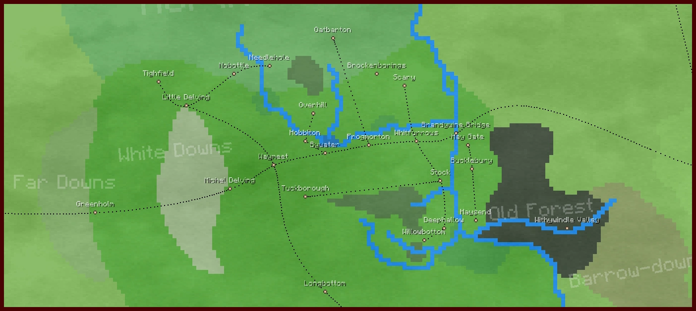
The predefined waypoints of the Shire.
Waypoints are points on the Middle-earth biome map which form the basis of the fast travel. There are two kinds of waypoints: Custom (displayed in white) and predefined (in beige).
Using the Map

Toggle labels.
Enter the Middle-earth menu (default "L"), click the arrows, until the map is displayed.
To toggle the display of labels on the map, click on the respective button "A" in the top right corner of the map.
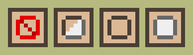
Toggle display: None - all - predefined - custom.
To toggle the display of the waypoints on the map, click on the respective button in the top right corner of the map. It cycles through the options none (red "0"), all (beige + white), predefined only (beige) and custom only (white) as shown in the picture to the left. The colours of the waypoints match those of the button. The "none" option also removes the roads from the map.
Custom Waypoints
Custom waypoints - displayed in white - can be created by players. In the beginning, the Mod allows you to set 5 custom waypoints per world. You can unlock more by earning achievements, which grant 1 extra custom waypoint per 5 Middle-earth achievements. This function is important to reach your buildings immediately as they are normally not right at the predefined fast travel points.
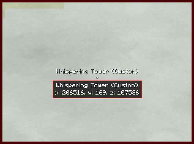
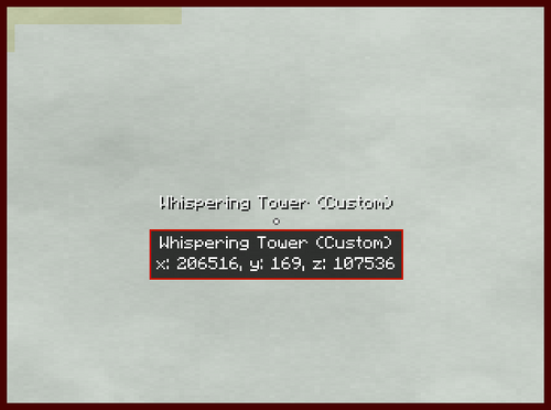
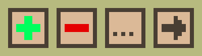
Manipulate custom waypoints: Add - remove - rename - share.
To add a new waypoint at your current position, open the map and click on the green "plus"-symbol. Then enter the name for the waypoint and press "enter" to confirm or "Esc" to cancel.
To delete a custom waypoint, click on it and press the red minus sign which will appear. Confirm that you really want to delete the waypoint. To rename a waypoint, press the button with the three dots. You will be prompted for a new name. Press "enter" to confirm or cancel with "Esc".
You can only create a waypoint at your current position. This is to prevent what would essentially be free teleportation to anywhere on the map without actually travelling there first. Custom waypoints can't be created in someone else's banner protected area.
Please note that these are player-specific, that is to say, custom waypoints you create will not be available (nor visible) to other players on multiplayer - unless you share your custom waypoint with your fellowship. Press the button with the arrow and then enter the fellowship's name. Other players may go to the same location and create their own custom waypoints there as well to gain access to the same spot.
Predefined Waypoints
Predefined waypoints (displayed in beige) are placed at a pre-set location, and all those waypoints have a name, of which most are taken from the Middle-earth canon. When you click on a waypoint, some lore related to it will be displayed.
Note: Major structures (like cities etc.) denoted by the waypoints are presently not implemented by the Mod (except for the villages of Bree-land). So, you will already find the Ring of Isengard (big wall) around the Isengard waypoint, but not the Orthanc tower itself. Waypoints denoting mountains will normally have the mountain generated nearby.
Roads pass through predefined waypoints, and the path the road takes is determined by the position of those waypoints.

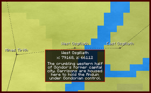
The total list of waypoints has been split up into different regions/biomes to help the reader not feel overwhelmed. Most of these list follow a pattern (starting here, going right, then down, then left, etc), but some biomes (such as the Shire) have so many waypoints that list has been put into alphabetical order. The regions are also those used in the command below.
Map coordinates are the position of the waypoint on the map.png in pixels, not the ingame coordinates. The top left corner is 0/0.
Game coordinates are the position as shown under the compass rose or by the F3-function while actually playing the game. It will be also displayed, when you click a waypoint or hover over the in-game map.
The descriptions are mainly taken from the in-game lore, enhanced by some additional info. If you are interested in more Middle-earth lore, please follow the links, that point to our twin wiki, The One Wiki to Rule Them All.
If you want to find info on a specific waypoint on this page, it's wise use the search function of your browser, normally Ctrl-F.
Island
- Himling - Map coordinates: 485 / 523 - Game coordinates: -41536 / -26432
- The peak of the hill of Himring (not typo!), mostly drowned following the War of Wrath. The small island is off the coast of northern Lindon. It was once an Elven citadel during the First Age.
- Tol Fuin - Map coordinates: 357 / 542 - Game coordinates: -57920 / -24000
- The highlands of Taur-nu-Fuin, the Forest under Nightshade, which survived the drowning of Beleriand. It is an island off the coast of Forlindon. It was once a corrupted forest in a mountain range.
- Tol Morwen – Map coordinates: 87 / 698 - Game coordinates: -92480 / -4032
- A lone hill spared in the drowning of Beleriand, upon which lay the grave of Morwen mother of Túrin Turambar. Also Finduilas, Niënor, and Túrin Turambar are buried on this island off the coast of Forlindon.
- The position of this secret island is classified information on this wiki. Don't add it here. Meneltarma can no longer be seen on the map if you have not yet sailed there.
- The summit of the Meneltarma, the Sacred Mountain, which alone survived the downfall of Númenor as an island in the Third Age. The name means "the Pillar of the Heavens".
The Shire
- Brandywine Bridge – Map coordinates: 853 / 725 - Game coordinates: 5568 / -576
- A bridge across the River Brandywine and out of the Shire. It is one of only three ways to cross the river without swimming. The others are the Bucklebury ferry and the Sarn Ford.
- Brockenborings – Map coordinates: 833 / 710 - Game coordinates: 3008 / -2496
- A warren of tunnels within the rocky hills surrounding Scary in the Eastfarthing of the Shire. Sometimes, it's also called "Brockenbores".
- Bucklebury – Map coordinates: 857 / 734 - Game coordinates: 6080 / 576
- The chief village of Buckland, home of the Master of Buckland in the far eastern part of the Shire. Their ferry offers one way to cross the Brandywine River without swimming.
- Bywater – Map coordinates: 820 / 730 - Game coordinates: 1344 / 64
- A village by the Pool upon the Water, home of the famous Green Dragon inn. It's on the Great East Road in the Westfarthing. Here Bywater Road branches off to Hobbiton and Overhill.
- Deephallow – Map coordinates: 850 / 749 - Game coordinates: 5184 / 2496
- A village upon the banks of the River Brandywine. It is located in the Southfarthing of the Shire close to the marshes.
- Frogmorton - Map coordinates: 831 / 728 - Game coordinates: 2752 / -192
- A village upon the East Road by the Frog-marshes. It is a marshy village in the Eastfarthing of the Shire.
- Greenholm - Map coordinates: 762 / 745 - Game coordinates: -6080 / 1984
- A small town upon the Far Downs at the western border of the Shire on the Great East Road.
- Hay Gate - Map coordinates: 856 / 728 - Game coordinates: 5952 / -192
- The guarded North Gate in the Hedge of Buckland. It's located southeast of the Brandywine Bridge.
- Haysend - Map coordinates: 858 / 747 - Game coordinates: 6208 / 2240
- A village in the south of Buckland at the end of the Hedge. It's located south of Bucklebury.
- Hobbiton - Map coordinates: 815 / 727 - Game coordinates: 704 / -320
- A town of Hobbits in the centre of the Shire, overlooked by the Hill of Bag End. It is most famous for being the original residence of Bilbo Baggins.
- Little Delving - Map coordinates: 785 / 718 - Game coordinates: -3136 / -1472
- A smaller Hobbit town upon the White Downs north of Michel Delving in the far west of the Shire.
- Longbottom - Map coordinates: 820 / 765 - Game coordinates: 1344 / 4544
- A town in the Southfarthing of the Shire, famous for its Longbottom Leaf. Named for the discovery of pipe-weed.
- Michel Delving - Map coordinates: 796 / 739 - Game coordinates: -1728 / 1216
- The chief town of the Shire, located in the White Downs, and home to the Mayor of Michel Delving. It is the largest town in all the Shire.
- Needlehole - Map coordinates: 806 / 708 - Game coordinates: -448 / -2752
- A town in the Westfarthing of the the Shire near the Northfarthing border.
- Nobottle - Map coordinates: 797 / 710 - Game coordinates: -1600 / -2496
- A town in the Westfarthing of the the Shire.
- Oatbarton - Map coordinates: 822 / 701 - Game coordinates: 1600 / -3648
- A village in the Northfarthing of the Shire.
- Overhill - Map coordinates: 817 / 720 - Game coordinates: 960 / -1216
- A small village north of Hobbiton and the Hill in the Northfarthing.
- Sarn Ford - Map coordinates: 883 / 802 - Game coordinates: 9408 / 9280
- Scary - Map coordinates: 840 / 713 - Game coordinates: 3904 / -2112
- A small Hobbit village among caves and stony hills in the Eastfarthing of the Shire.
- Stock - Map coordinates: 849 / 737 - Game coordinates: 5056 / 960
- A town upon the Stock-brook by the banks of the River Brandywine in the Eastfarthing of the Shire. It's about across the Brandywine from Bucklebury.
- Tighfield - Map coordinates: 778 / 712 - Game coordinates: -4032 / -2240
- A village known for its rope-makers in the Westfarthing of the Shire.
- Tuckborough - Map coordinates: 815 / 741 - Game coordinates: 704 / 1472
- A historic town within the Green-hill Country. Home to the Took family, the Thains of the the Shire.
- Waymeet - Map coordinates: 807 / 733 - Game coordinates: -320 / 448
- Whitfurrows - Map coordinates: 843 / 727 - Game coordinates: 4288 / -320
- A small town upon the East Road in the Eastfarthing of the Shire.
- Willowbottom - Map coordinates: 845 / 752 - Game coordinates: 4544 / 2880
- A small village near the Woody End in the Eastfarthing of the Shire.
Old Forest
- Withywindle Valley - Map coordinates: 881 / 749 - Game coordinates: 9152 / 2496
- A strange and haunted valley where the Withywindle runs through the Old Forest. The river is a tributary of the Brandywine River. Tom Bombadil lives nearby it.
Lindon
- Forlindon - Map coordinates: 532 / 638 - Game coordinates: -35520 / -11712
- The northern regions of the fair country of Lindon.
- Forlond - Map coordinates: 526 / 718 - Game coordinates: -36288 / -1472
- A harbour-city of the Elves on the northern shore of the Gulf of Lune on the southern part of Forlindon.
- North Mithlond - Map coordinates: 669 / 717 - Game coordinates: -17984 / -1600
- The northern half of Mithlond, the Grey Havens, where Círdan the Shipwright dwells with his people. A great elven port in Lindon.
- South Mithlond - Map coordinates: 679 / 729 - Game coordinates: -16704 / -64
- The southern half of Mithlond, the Grey Havens, where Círdan the Shipwright dwells with his people. A great elven port in Lindon.
- Harlond - Map coordinates: 605 / 783 - Game coordinates: -26176 / 6848
- A harbour-city of the Elves on the southern shore of the Gulf of Lune on the northern part of Harlindon.
- Harlindon - Map coordinates: 611 / 878 - Game coordinates: -25408 / 19008
- The southern regions of the fair country of Lindon.
- Elostirion - Map coordinates: 710 / 742 - Game coordinates: -12736 / 1600
- Tallest of the White Towers built for Elendil by Gil-galad, said to house one of the Seeing Stones of Arnor. It is located in the Tower Hills, a range of hills on the eastern border of Lindon.
- Amon Ereb - Map coordinates: 500 / 708 - Game coordinates: -39616 / -2752
- An ancient hill in Lindon, which, long ago in the Elder Days, was a lookout-post of great importance in the southeast of Forlindon.
Blue Mountains
- Belegost - Map coordinates: 622 / 600 - Game coordinates: -24000 / -16576
- An ancient Dwarven city of the Blue Mountains, dating back to the Elder Days. It was destroyed after the War of Wrath, but later resettled, in part.
- Nogrod - Map coordinates: 626 / 636 - Game coordinates: -23488 / -11968
- An ancient Dwarven city of the Blue Mountains, dating back to the Elder Days. It was destroyed after the War of Wrath, but later resettled, in part.
- Thorin's Halls - Map coordinates: 641 / 671 - Game coordinates: -21568 / -7488
- Once ruled by Thorin Oakenshield, this settlement in the Blue Mountains is inhabited by Dwarves mostly of Durin's Folk. It was established after they were driven out of Erebor by Smaug.
- Mount Dolmed - Map coordinates: 599 / 627 - Game coordinates: -26944 / -13120
- Said to be the awakening-place of two Fathers of the Dwarves, this mountain was cloven in the War of Wrath and diminished in size.
- Mount Rerir - Map coordinates: 592 / 525 - Game coordinates: -27840 / -26176
- A large mountain, once the source of a great river, but ruined during the War of Wrath. During the First Age, the elf Caranthir build a fortress at the base of the mountain.
- Arvedui's Mines - Map coordinates: 663 / 489 - Game coordinates: -18752 / -30784
- Abandoned mines in the Blue Mountains. The last King of Arnor Arvedui and his company once hid here in his later days to escape the threat of Angmar.
- Thráin's Halls - Map coordinates: 669 / 793 - Game coordinates: -17984 / 8128
- A Dwarven settlement, founded by Thráin and the exiles of the Lonely Mountain, with many old mines still in use today.
Eriador
- Annúminas - Map coordinates: 814 / 661 - Game coordinates: 576 / -8768
- The old capital of Arnor, the North-kingdom, before it was abandoned in favour of Fornost Erain. It's located north of the Shire.
- Fornost - Map coordinates: 897 / 652 - Game coordinates: 11200 / -9920
- Fornost Erain, the ruined capital of Arnor. Known as Kings' Norbury in the Common Tongue. It was also the capital of Arthedain.
- North Downs - Map coordinates: 930 / 626 - Game coordinates: 15424 / -13248
- A range of hills in northern Eriador with the ancient city of Fornost Erain at their southwestern end. It's located north of Bree.
- South Downs - Map coordinates: 960 / 768 - Game coordinates: 19264 / 4928
- Greenway Crossroads - Map coordinates: 920 / 810 - Game coordinates: 14144 / 10304
- The crossing of the great East-West and North-South roads.
- Tharbad - Map coordinates: 979 / 878 - Game coordinates: 21696 / 19008
- An old ford-town in Eriador, deserted following the Great Plague. It's a fortified town on the River Greyflood, in the southern edge of Eriador.
- Eryn Vorn - Map coordinates: 747 / 957 - Game coordinates: -8000 / 29120
- These dark woodlands are among the last remnants of the ancient forest that once covered all Eriador. It is a cape in the very south of Minhiriath.
Bree-land
- Bree - Map coordinates: 915 / 734 - Game coordinates: 13504 / 576
- The chief town of the Bree-land, known for its cheerful Men and Hobbits. It is located on the crossing of the Great East Road and the Greenway east of the Shire.
- Staddle - Map coordinates: 923 / 736 - Game coordinates: 14528 / 832
- A town of Hobbits in the Bree-land. It is located in the south-east of Bree-land on the Great East Road.
- Combe - Map coordinates: 927 / 731 - Game coordinates: 15040 / 192
- A village of Men on the road to the Chetwood.
- Archet - Map coordinates: 929 / 726 - Game coordinates: 15296 / -448
- A town of the Bree-folk on the edge of the Chetwood with a lively logging trade.
- Forsaken Inn - Map coordinates: 950 / 743 - Game coordinates: 17984 / 1728
- A day's ride east of Bree, this lonely inn is the last settlement of Men before the wild lands. It is an abandoned outpost.
Lone-lands
- Weathertop - Map coordinates: 998 / 723 - Game coordinates: 24128 / -832
- The ruined watchtower of Amon Sûl. In olden days it housed one of the great Seeing Stones of Arnor. It's southernmost and highest summit of the Weather Hills.
- The Last Bridge - Map coordinates: 1088 / 714 - Game coordinates: 35648 / -1984
- The last bridge on the Great East Road before the Misty Mountains. As the only crossing of the river Mitheithel, the Bridge of Mitheithel was an ancient stone bridge (although it is a wooden bridge in the mod).
- Old Elven Way - Map coordinates: 1028 / 847 - Game coordinates: 27968 / 15040
Rivendell Vale
- Ford of Bruinen - Map coordinates: 1163 / 723 - Game coordinates: 45248 / -832
- Rivendell - Map coordinates: 1173 / 721 - Game coordinates: 46528 / -1088
- The hidden valley of Imladris, where Lord Elrond and Lady Arwen dwell with their people in the Last Homely House East of the Sea.
Trollshaws
- Trollshaws - Map coordinates: 1130 / 703 - Game coordinates: 41024 / -3392
Angmar
- Carn Dûm - Map coordinates: 1010 / 503 - Game coordinates: 25664 / -28992
- The capital of the old Kingdom of Angmar. The old stronghold of the Witch-king.
Eregion
- Ost-in-Edhil - Map coordinates: 1112 / 870 - Game coordinates: 38720 / 17984
- The ruined city of the Elves of Eregion. It was ruled by Celebrimbor.
- West Gate - Map coordinates: 1134 / 873 - Game coordinates: 41536 / 18368
- The western gate of Khazad-dûm, now called Moria: of old the great delvings and mansions of the Dwarves of Durin's Folk and a wonder of the Northern world.
Dunland
- Duneard - Map coordinates: 1073 / 946 - Game coordinates: 33728 / 27712
- A northern village of shepherds and hunters in the northern reaches of Dunland.
- Dwarrowvale - Map coordinates: 1080 / 990 - Game coordinates: 34624 / 33344
- A Dunlending village grown up around the site of an old hamlet, which, it is said, once hosted Thráin and Thorin Oakenshield during their long wanderings in the wild.
- Firwold - Map coordinates: 1070 / 1027 - Game coordinates: 33344 / 38080
- A town of middling size in the highs of Dunland, and a stop for many traders and travellers on their journeys through the region.
- Fords of Isen - Map coordinates: 1102 / 1087 - Game coordinates: 37440 / 45760
- These shallow fords across the River Isen into Rohan are often the site of skirmishes between the Rohirrim and the Orcs.
- Wulfburg - Map coordinates: 1077 / 1098 - Game coordinates: 34240 / 47168
- Once the fortress of Freca's son, the self-styled 'King' Wulf, who seized Meduseld for Dunland during the reign of Helm Hammerhand.
Enedwaith
- Lond Daer - Map coordinates: 867 / 1004 - Game coordinates: 7360 / 35136
- The ancient ruins of the first Númenórean haven in Middle-earth. It is located at the mouth of River Greyflood in the south of Enedwaith.
- Old South Road - Map coordinates: 1025 / 1050 - Game coordinates: 27584 / 41024
- With the North-kingdom long fallen and the power of the South-kingdom waning, these stretches of the old Royal Road have long since fallen into ruin. It leads to the Fords of Isen from the West.
- Mouths of Isen - Map coordinates: 871 / 1127 - Game coordinates: 7872 / 50880
- Here the River Isen flows into the Sea after its long course through sparsely-inhabited Enedwaith.
Nan Curunír
- Isengard - Map coordinates: 1102 / 1058 - Game coordinates: 37440 / 42048
- A great fortified ring of stone within a vale at the very south of Misty Mountains, wherein stands the tower of Orthanc, stronghold of Saruman.
Forodwaith and Northlands
- Cape of Forochel - Map coordinates: 786 / 390 - Game coordinates: -3008 / -43456
- The perilous floes of the Icebay, where only the Snowmen of Forochel dare wander. It's located in the west of Forodwaith.
- South Forochel - Map coordinates: 825 / 459 - Game coordinates: 1984 / -34624
- One of few permanent settlements of the Lossoth among the frozen wastes. It's located in the west of Forodwaith.
- Withered Heath - Map coordinates: 1441 / 556 - Game coordinates: 80832 / -22208
- A scorched valley in the east of the Grey Mountains where, it is said, lurk the last of the Fire-drakes.
Grey Mountains
- Dáin's Halls - Map coordinates: 1262 / 554 - Game coordinates: 57920 / -22464
- A colony of Durin's Folk in the west of Grey Mountains, abandoned after Dáin was slain by a Cold-drake.
- Scatha's Lair - Map coordinates: 1335 / 562 - Game coordinates: 67264 / -21440
- Once the lair of Scatha, a great Long-worm, before he was slain by Fram of the Éothéod. Scatha ruled the Grey Mountains long ago.
Misty Mountains
- Mount Gram - Map coordinates: 1106 / 589 - Game coordinates: 37952 / -17984
- A mountain inhabited by Orcs who often trouble the lands of Eriador in the north west of the Misty Mountains.
- Mount Gundabad - Map coordinates: 1195 / 592 - Game coordinates: 49344 / -17600
- The mountain beneath which Durin the Deathless awoke in the Elder Days, and a sacred site of the Dwarves before being overrun by Orcs.
- Goblin Town - Map coordinates: 1220 / 696 - Game coordinates: 52544 / -4288
- A warren of weaving tunnels and caverns beneath the High Pass, where Orcs scutter and scrape in the dark. A large goblin dwelling in the Misty Mountains, ruled by the Great Goblin.
- Eagles Eyrie - Map coordinates: 1246 / 685 - Game coordinates: 55872 / -5696
- A great shelf of rock on the eastern side of the Misty Mountains that can be reached only by flight. The Eagles of Manwë reside here.
- High Pass - Map coordinates: 1222 / 706 - Game coordinates: 52800 / -3008
- A long and perilous mountain pass from Eriador into Wilderland where the Great East Road crosses the Misty Mountains.
- Mount Celebdil - Map coordinates: 1158 / 864 - Game coordinates: 44608 / 17216
- The Silvertine, one of the three peaks above Khazad-dûm. Upon its summit stands the fabled Durin's Tower.
- Mount Caradhras - Map coordinates: 1166 / 845 - Game coordinates: 45632 / 14784
- The Redhorn, the tallest of the three peaks above the delvings of Khazad-dûm. The mountain is called Caradhras the Cruel and is said to have a will of its own.
- Mount Fanuidhol - Map coordinates: 1191 / 854 - Game coordinates: 48832 / 15936
- The Cloudyhead, one of three peaks above the realm of Khazad-dûm.
- Mount Methedras - Map coordinates: 1111 / 1031 - Game coordinates: 38592 / 38592
- The Last Peak, southernmost of the Misty Mountains, whence flow the rivers Isen and Entwash.
Vales of Anduin
- Framsburg - Map coordinates: 1251 / 590 - Game coordinates: 56512 / -17856
- Forest Gate - Map coordinates: 1303 / 655 - Game coordinates: 63168 / -9536
- Once the entrance to the Wood-elven realm in Greenwood the Great, the gate of Mirkwood is now defiled by servants of the Enemy.
- Carrock - Map coordinates: 1281 / 681 - Game coordinates: 60352 / -6208
- A towering pillar of rock in the midst of the Great River. It was once said that, on clear nights, a great bear could be seen climbing the rock to gaze upon the Moon.
- Beorn's Hall - Map coordinates: 1302 / 680 - Game coordinates: 63040 / -6336
- A rustic homestead inhabited by skin-changers and men of the Vales, said to be unfriendly to outsiders.
- Old Ford - Map coordinates: 1284 / 702 - Game coordinates: 60736 / -3520
- The crossing of the Old Forest Road upon the Great River of Wilderland. A bridge once stood here, but has long since crumbled. Now, it's a strategic ford.
- Gladden Confluence - Map coordinates: 1294 / 790 - Game coordinates: 62016 / 7744
- The watery meeting-place where the Gladden flows down into the Great River Anduin.
- Dimrill Dale - Map coordinates: 1177 / 864 - Game coordinates: 47040 / 17216
- Azanulbizar, below the East Gate of Khazad-dûm: The valley of the Lake Mirrormere, wherein it is said Durin the Deathless first saw his crown among the stars.
- Crossroads of Anduin - Map coordinates: 1285 / 905 - Game coordinates: 60864 / 22464
- A fork in the path between the Anduin Road and the road to Dol Guldur.
- Field of Celebrant - Map coordinates: 1281 / 960 - Game coordinates: 60352 / 29504
- The site of the Gondor-Éothéod victory over the Balchoth, which led to the historic Oath of Eorl and Cirion.
- East Rhovanion Gate - Map coordinates: 1354 / 966 - Game coordinates: 69696 / 30272
- An old crossroads at the meeting of the Anduin Vales, the Brown Lands, and eastern Wilderland.
- Rauros - Map coordinates: 1345 / 1130 - Game coordinates: 68544 / 51264
- The shores of Parth Galen by the great falls of Rauros, a waterfall which carried water from the river Anduin through Emyn Muil and into Nindalf.
Woodland Realm
- Thranduil's Halls - Map coordinates: 1420 / 633 - Game coordinates: 78144 / -12352
Mirkwood
- Enchanted River - Map coordinates: 1396 / 650 - Game coordinates: 75072 / -10176
- Here the Elf-path crosses over a gloomy black river that flows from the Mountains of Mirkwood into the forest. It is advised to avoid these waters, for whoever touches them shall not awake...
- Mountains of Mirkwood - Map coordinates: 1430 / 672 - Game coordinates: 79424 / -7360
- The Emyn-nu-Fuin, a range of dark hills rising out of the fog of Mirkwood, which fence out the worst of the Necromancer's corruption.
- Rhosgobel - Map coordinates: 1343 / 762 - Game coordinates: 68288 / 4160
- The dwelling-place of the wizard Radagast the Brown, home to many birds and beasts, and a safe haven among the corruption of Mirkwood.
- Dol Guldur - Map coordinates: 1339 / 894 - Game coordinates: 67776 / 21056
- Fortress-lair of the Necromancer before he fled eastwards, now inhabited by Khamûl the Easterling and his fell servants.
Wilderland
- River Gate - Map coordinates: 1474 / 696 - Game coordinates: 85056 / -4288
- An outpost of the Wood-elves at the end of the Old Forest Road, where it meets the River Running.
- East Bight - Map coordinates: 1437 / 824 - Game coordinates: 80320 / 12096
- Old Rhovanion - Map coordinates: 1524 / 870 - Game coordinates: 91456 / 17984
- Long ago, these lands were held by a great Mannish kingdom of Rhovanion, but now its ruins are all that remain.
- Dorwinion Crossroads - Map coordinates: 1680 / 882 - Game coordinates: 111424 / 19520
Dale
- Erebor - Map coordinates: 1463 / 609 - Game coordinates: 83648 / -15424
- The Lonely Mountain. Herein lies the Kingdom under the Mountain, a realm of Durin's Folk.
- Dale - Map coordinates: 1464 / 615 - Game coordinates: 83776 / -14656
- The prosperous city of the Kingdom of Dale at the foot of the Lonely Mountain. It was destroyed by Smaug the Terrible in days of old, but rebuilt under King Bard.
- Long Lake - Map coordinates: 1461 / 632 - Game coordinates: 83392 / -12480
- Great Dalish Crossroads - Map coordinates: 1567 / 680 - Game coordinates: 96960 / -6336
- At the meeting of several important Dalish roads, the lands around this crossing are home to many guilds and thriving markets.
- Running Ford - Map coordinates: 1534 / 749 - Game coordinates: 92736 / 2496
- A shallow ford on the River Running where the road runs south to old Rhovanion.
- Redwater Ford - Map coordinates: 1651 / 690 - Game coordinates: 107712 / -5056
- A ford on the Redwater at the eastern border of the Kingdom of Dale, upon the ancient East-West Road laid by the Dwarves.
- Bardhaven - Map coordinates: 1657 / 768 - Game coordinates: 108480 / 4928
- The southern port of the Kingdom of Dale, and an important point on the trade routes of Dorwinion.
Iron Hills
- West Peak - Map coordinates: 1588 / 608 - Game coordinates: 99648 / -15552
- The nearer of two large peaks in the Iron Hills. Beneath are the halls of Dáin Ironfoot.
- East Peak - Map coordinates: 1729 / 610 - Game coordinates: 117696 / -15296
- A large mountain in the far eastern end of the Iron Hills.
Lothlórien
- House of Nimrodel - Map coordinates: 1198 / 894 - Game coordinates: 49728 / 21056
- The former home of an Elf-maiden, Nimrodel, who disappeared grieving after her beloved Amroth was drowned in the Sundering Seas.
- Cerin Amroth - Map coordinates: 1230 / 897 - Game coordinates: 53824 / 21440
- A great green hill in the midst of Lothlórien from where it is said one may see as far as southern Mirkwood, ringed with trees.
- Caras Galadhon - Map coordinates: 1242 / 902 - Game coordinates: 55360 / 22080
- The city of the Galadhrim in Lothlórien, and the heart of Elvendom on earth, where all the homes are built in trees.
Fangorn
- Wellinghall - Map coordinates: 1153 / 1014 - Game coordinates: 43968 / 36416
- One of Treebeard's Ent-houses nestled among the spurs of Mount Methedras.
- Derndingle - Map coordinates: 1163 / 1030 - Game coordinates: 45248 / 38464
- Treebeard's Hill - Map coordinates: 1200 / 1030 - Game coordinates: 49984 / 38464
- A rocky shelf, standing above the trees of Fangorn Forest, where one can contemplate the sunlight on the leaves and the wind among their branches.
Rohan
- Uruk Highlands - Map coordinates: 1131 / 1057 - Game coordinates: 41152 / 41920
- These lands in the foothills of the Misty Mountains once belonged to Rohan, but are now desolate and burnt by the servants of the White Hand.
- Deeping-coomb - Map coordinates: 1136 / 1108 - Game coordinates: 41792 / 48448
- A highly defended vale at the foot of Helm's Deep.
- Helm's Deep - Map coordinates: 1128 / 1115 - Game coordinates: 40768 / 49344
- The greatest Rohirric fortress, the Hornburg, which stands in a wide vale beneath the Thrihyrne. Men say that its Deeping Wall has never to this day been breached.
- Grimslade - Map coordinates: 1153 / 1122 - Game coordinates: 43968 / 50240
- The childhood home of Grimbold, a Marshal of the Riddermark.
- Edoras - Map coordinates: 1190 / 1148 - Game coordinates: 48704 / 53568
- The chief city of the Riddermark, built upon a hill crowned with the Golden Hall of Meduseld.
- Entwade - Map coordinates: 1239 / 1104 - Game coordinates: 54976 / 47936
- Woldhall - Map coordinates: 1285 / 1015 - Game coordinates: 60864 / 36544
- A small town in the sparsely inhabited uplands of Rohan.
- Eastmark - Map coordinates: 1286 / 1130 - Game coordinates: 60992 / 51264
- The heart of the wide lands patrolled by the eastern Riders of Rohan.
- Aldburg - Map coordinates: 1223 / 1178 - Game coordinates: 52928 / 57408
- The first capital of Rohan, Aldburg is the oldest town in the Riddermark and the seat of the Third Marshal of the Rohirrim.
- Mering Stream - Map coordinates: 1299 / 1202 - Game coordinates: 62656 / 60480
- This stream marks the border between Rohan and Gondor. It runs through Firienholt, the Whispering Wood.
- Corsair´s Landing - Map coordinates: 992 / 1113 - Game coordinates: 23360 / 49088
- In the days of Helm Hammerhand, a fleet of Southrons landed here and fought alongside the Dunlendings to defeat the Men of Rohan.
- Freca´s Hold - Map coordinates: 1099 / 1144 - Game coordinates: 37056 / 53056
- The old fort raised by the heedless Lord Freca, who ruled the lands around the River Adorn, and was said to be part-Dunlending.
White Mountains
- Ras Morthil - Map coordinates: 845 / 1332 - Game coordinates: 4544 / 77120
- The last peak at the headland in the very west of the White Mountains. The Men of Anfalas say that wild Púkel-men still linger in these lands.
- Dunharrow - Map coordinates: 1175 / 1154 - Game coordinates: 46784 / 54336
- A refuge of the Rohirrim beneath the Dwimorberg, the Haunted Mountain. It is said that none living may pass the Paths of the Dead.
- Tarlang's Neck - Map coordinates: 1205 / 1213 - Game coordinates: 50624 / 61888
- Men say that a giant fell here and broke his neck, forming the mountain pass between the Blackroot Vale and Lamedon.
Gondor
- Halifirien - Map coordinates: 1309 / 1205 - Game coordinates: 63936 / 60864
- The Holy Mountain, westernmost of the beacon-hills of Gondor. Elendil was once entombed here, and Cirion and Eorl swore their Oath upon its slopes.
- Calenhad - Map coordinates: 1330 / 1212 - Game coordinates: 66624 / 61760
- The sixth beacon-hill, lit only in times of urgency.
- Min-Rimmon - Map coordinates: 1350 / 1219 - Game coordinates: 69184 / 62656
- The fifth beacon-hill and one of the oldest, established before the founding of Rohan.
- Erelas - Map coordinates: 1367 / 1222 - Game coordinates: 71360 / 63040
- The fourth beacon-hill of Gondor. Bare and treeless, it is easily sighted from the surrounding lands.
- Nardol - Map coordinates: 1384 / 1228 - Game coordinates: 73536 / 63808
- The third beacon-hill, built on a stretch of the White Mountains. On a clear night its fire is said to be seen all the way from the Halifirien.
- Eilenach - Map coordinates: 1402 / 1228 - Game coordinates: 75840 / 63808
- The second beacon-hill from Minas Tirith, and the highest point of the Drúadan Forest.
- Amon Dîn - Map coordinates: 1416 / 1231 - Game coordinates: 77632 / 64192
- The Silent Hill is the closest beacon to Minas Tirith. Overlooking northern Ithilien, it serves as a fortified outpost for the White City.
- Cair Andros - Map coordinates: 1427 / 1207 - Game coordinates: 79040 / 61120
- A fortified island in the middle of the river Anduin, named for the white foam of the waters that run beside it.
- West Osgiliath - Map coordinates: 1428 / 1246 - Game coordinates: 79168 / 66112
- Minas Tirith - Map coordinates: 1419 / 1247 - Game coordinates: 78016 / 66240
- The great Tower of Guard, capital city of the kingdom of Gondor, built of seven levels of pure white stone with the white Tower of Ecthelion at its summit.
Ithilien
- North Ithilien - Map coordinates: 1447 / 1151 - Game coordinates: 81600 / 53952
- The northern reaches of the Land of the Moon.
- Henneth Annûn - Map coordinates: 1443 / 1192 - Game coordinates: 81088 / 59200
- The Forbidden Pool of Ithilien, where the Window-curtain waterfall masks a secret refuge.
- Crossroads of the Fallen King - Map coordinates: 1450 / 1236 - Game coordinates: 81984 / 64832
- These neglected crossroads once housed a majestic statue of a King, which, though now ruined, still wears a coronal of silver and gold.
- East Osgiliath - Map coordinates: 1435 / 1246 - Game coordinates: 80064 / 66112
- The ruined eastern half of Gondor’s former capital city, now often the site of clashes between Gondorians and Orcs. The eastern portion is located in Ithilien.
- Emyn Arnen - Map coordinates: 1437 / 1267 - Game coordinates: 80320 / 68800
- In better days these hills in southern Ithilien were the residence of some noble and wealthy Gondorian families, including the House of the Stewards.
- Crossings of Poros - Map coordinates: 1442 / 1370 - Game coordinates: 80960 / 81984
- The crossing into Harondor over the River Poros. Nearby stands a great mound, wherein rest the twin sons of King Folcwine.
Lossarnach
- Crossing of Erui - Map coordinates: 1412 / 1272 - Game coordinates: 77120 / 69440
- The fords of the River Erui in Lossarnach. Many Gondorians once perished here in the Kin-strife.
- Imloth Melui - Map coordinates: 1397 / 1254 - Game coordinates: 75200 / 67136
- The sweet Valley of Roses within Lossarnach.
Lebennin
- Pelargir - Map coordinates: 1390 / 1348 - Game coordinates: 74304 / 79168
- The great royal havens of the Ship-kings: The chief harbour of Gondor on the banks of the river Anduin.
- Linhir - Map coordinates: 1292 / 1342 - Game coordinates: 61760 / 78400
- Ethir Anduin - Map coordinates: 1273 / 1369 - Game coordinates: 59328 / 81856
Lamedon
- Ethring - Map coordinates: 1256 / 1259 - Game coordinates: 57152 / 67776
- A long bridge in the Ringló Vale on the road from Pelargir to Erech in southern Gondor.
- Calembel - Map coordinates: 1235 / 1248 - Game coordinates: 54464 / 66368
- A capital of the province Lamedon near the fords of the River Ciril, with few inhabitants.
Blackroot Vale
- Erech - Map coordinates: 1186 / 1205 - Game coordinates: 48192 / 60864
- A great steep hill, believed to be haunted, and known for the mysterious black stone which stands upon the summit.
Pinnath Gelin
- Pinnath Gelin - Map coordinates: 1045 / 1273 - Game coordinates: 30144 / 69568
- The beautiful Green Hills in western Gondor.
Dor-en-Ernil
- Tarnost - Map coordinates: 1241 / 1300 - Game coordinates: 55232 / 73024
- Edhellond - Map coordinates: 1189 / 1293 - Game coordinates: 48576 / 72128
- Dol Amroth - Map coordinates: 1158 / 1333 - Game coordinates: 44608 / 77248
- A mighty castle and city upon the shores of Belfalas, ruled by the Prince of Dol Amroth, a subject of Gondor.
Tolfalas
- Tolfalas - Map coordinates: 1240 / 1414 - Game coordinates: 55104 / 87616
Emyn Muil
- Amon Hen - Map coordinates: 1335 / 1131 - Game coordinates: 67264 / 51392
- The Hill of Sight, an ancient seat of Gondorian power, located near Rauros.
- Argonath - Map coordinates: 1347 / 1112 - Game coordinates: 68800 / 48960
- The Pillars of the Kings: Two mighty statues of Isildur and Anárion beside the Anduin, which guard what was once the northern border of Gondor.
- Amon Lhaw - Map coordinates: 1372 / 1120 - Game coordinates: 72000 / 49984
- The Hill of Hearing, an ancient seat of Gondorian power.
Brown Lands
- North Undeep - Map coordinates: 1319 / 988 - Game coordinates: 65216 / 33088
- The northern of two westward bends in the Great River Anduin. The shallow fords of the Undeeps were often used by armies as a crossing-point.
- South Undeep - Map coordinates: 1335 / 1024 - Game coordinates: 67264 / 37696
- The southern of two westward bends in the Great River Anduin. The shallow fords of the Undeeps were often used by armies as a crossing-point.
Dagorlad
- Black Gate - Map coordinates: 1470 / 1131 - Game coordinates: 84544 / 51392
- The great gates of Mordor, wrought of twisted steel and dark stone. None pass unless the Eye of the Dark Tower wills it.
Mordor
- Valley of Udûn - Map coordinates: 1470 / 1145 - Game coordinates: 84544 / 53184
- The Orc-infested vale between the Black Gate and the Isenmouthe. Named in imitation of Udûn, the first fortress of Morgoth, also called Utumno.
- Durthang - Map coordinates: 1464 / 1159 - Game coordinates: 83776 / 54976
- A powerful Orcish stronghold built upon the slopes of Ephel Dúath.
- Carach Angren - Map coordinates: 1493 / 1166 - Game coordinates: 87488 / 55872
- The Iron Teeth, a guarded mountain pass between Udûn and the plateau of Gorgoroth. It was barricaded by a wall of earth, surrounded with war-towers, and included a deep ravine spanned by a bridge in front of the single gate.
- Barad-Dûr - Map coordinates: 1573 / 1196 - Game coordinates: 97728 / 59712
- The Dark Tower: Immeasurably strong and unconquerable fortress of Sauron, Lord of the Earth, and the seat from which all the evil hosts of Mordor are bent to his will. Mountain of iron, wall of steel, tower of adamant.
- Mount Doom - Map coordinates: 1533 / 1204 - Game coordinates: 92608 / 60736
- Cirith Ungol - Map coordinates: 1479 / 1225 - Game coordinates: 85696 / 63424
- The dark and twisted Spider's Cleft within the mountains of Mordor, watched over by an evil guard-tower. The pass leads into the plateau of Gorgoroth.
- Minas Morgul - Map coordinates: 1461 / 1239 - Game coordinates: 83392 / 65216
- Once Minas Ithil, the fair Tower of the Moon; now a dark and sickly place ruled by the Lord of the Nazgûl.
- Mornost - Map coordinates: 1558 / 1286 - Game coordinates: 95808 / 71232
- A watch-post upon the shadowy spurs of the Ephel Dúath which, along with Nargroth eastward, watched the way into Núrn.
- Narroth - Map coordinates: 1640 / 1248 - Game coordinates: 106304 / 66368
- The Halls of Fire, a watchtower above the pass into the plateau of Gorgoroth,that, along with Morigost, watches the way into Núrn.
- Amon Angren - Map coordinates: 1663 / 1245 - Game coordinates: 109248 / 65984
- Seregost - Map coordinates: 1682 / 1214 - Game coordinates: 111680 / 62016
- A fortress in the Mountains of Mordor guarding a pass in the Mithram Spur. The armies of the Easterlings pass through here on the road to Barad-dûr.
- Vale of the Fell Beasts - Map coordinates: 1754 / 1164 - Game coordinates: 120896 / 55616
- A dark valley behind the walls of Mordor infested with fell beasts and evil creatures.
- Eastern Guard - Map coordinates: 1840 / 1137 - Game coordinates: 131904 / 52160
Nan Ungol
- Valley of Spiders - Map coordinates: 1512 / 1400 - Game coordinates: 89920 / 85824
Nurn
- Thorband - Map coordinates: 1643 / 1354 - Game coordinates: 106688 / 79936
- Dunurnen - Map coordinates: 1650 / 1363 - Game coordinates: 107584 / 81088
- The sad western shores of the Sea of Núrnen.
- Fornurnen - Map coordinates: 1696 / 1324 - Game coordinates: 113472 / 76096
- The dreary northern shores of the Sea of Núrnen.
- Harnurnen - Map coordinates: 1718 / 1369 - Game coordinates: 116288 / 81856
- The bleak southern shores of the Sea of Núrnen.
- Rhunurnen - Map coordinates: 1758 / 1316 - Game coordinates: 121408 / 75072
- The dim eastern shores of the Sea of Núrnen.
Dorwinion
- Mirulond - Map coordinates: 1784 / 863 - Game coordinates: 124736 / 17088
- The Wine-havens upon the Celduin, where the Avari Elves of Dorwinion receive shipments from their kin in the Woodland Realm.
- Vintner Court - Map coordinates: 1758 / 939 - Game coordinates: 121408 / 26816
- Amon Gwîn - Map coordinates: 1733 / 950 - Game coordinates: 118208 / 28224
- A high peak in the hills of Dorwinion.
- Golden Ford - Map coordinates: 1776 / 986 - Game coordinates: 123712 / 32832
Rhûn
- Redway - Map coordinates: 2228 / 835 - Game coordinates: 181568 / 13504
- A far stretch of the ancient Dwarf-road that runs eastward to the great halls and mansions of the Orocarni.
- North Khand Road - Map coordinates: 1932 / 1331 - Game coordinates: 143680 / 76992
- Balcharas - Map coordinates: 2231 / 1058 - Game coordinates: 181952 / 42048
- A city of the Wainriders and one of their few permanent dwelling-places in the wide lands of the East.
Rhúdel
- Taragal - Map coordinates: 1794 / 979 - Game coordinates: 126016 / 31936
- Belrhuk - Map coordinates: 1837 / 956 - Game coordinates: 131520 / 28992
- A town close to the heart of Rhúdel. It is said that here, on the clearest days, one can glimpse the Isle in the Sea among the far mists.
- Rhúnost - Map coordinates: 1867 / 984 - Game coordinates: 135360 / 32576
- The greatest city of Rhûn, palace and fortress of the King of the East. Its high towers are wreathed in mist and its mighty gates are inlaid with gold.
- Pass of Rhúdel - Map coordinates: 1869 / 1055 - Game coordinates: 135616 / 41664
- It is said that this mountain pass was once the lair of a great Were-worm out of the South, until Lord Sauron cast the beast into long sleep with a mighty spell.
- Ashen Ford - Map coordinates: 1834 / 1112 - Game coordinates: 131136 / 48960
- The waters of this ford run grey with foul ash. Here, Easterlings may follow the road down into Mordor, or take the long march West. It's located in the very south of Rhúdel.
- Southern Marches - Map coordinates: 1900 / 1141 - Game coordinates: 139584 / 52672
The southern frontier of Rhúdel, where the road runs on to Sauron's servants in Khand and the Harad.
- Atalak - Map coordinates: 1903 / 914 - Game coordinates: 139968 / 23616
- The bustling markets and twisting streets of this Easterling seaport city are said to confuse travellers from all lands.
- Bazylan - Map coordinates: 1921 / 889 - Game coordinates: 142272 / 20416
- A city of the Easterlings, said to be founded by a mighty nobleman of legend and named for his beloved cat.
- Khamûl's Tower - Map coordinates: 1888 / 878 - Game coordinates: 138048 / 19008
- The sorcerous tower of Khamûl, a cruel king of Easterlings in the Second Age.
- Ford of Forunen - Map coordinates: 1942 / 811 - Game coordinates: 144960 / 10432
- A ford across the River Forunen on the ancient East-West Road.
- Northern Marches - Map coordinates: 2045 / 815 - Game coordinates: 158144 / 10944
- The northern frontier of Rhúdel, a place of deep bogs and tall brown reeds thick with the terrible air of decay.
- Karanoda - Map coordinates: 1983 / 936 - Game coordinates: 150208 / 26432
- A small fortified town on the east road to the city of Karslan.
- Karslan - Map coordinates: 2010 / 962 - Game coordinates: 153664 / 29760
- An eastern city of Rhúdel beyond the hills. Trade passes from here down through the wide lands of Rhûn and into the Gulf of Harad.
Red Mountains
- Baraz-tûm - Map coordinates: 2326 / 800 - Game coordinates: 194112 / 9024
- The Red Delvings: Mansions of the Eastern Dwarves beneath the peaks of the Orocarni.
Lostladen
- Khandwater Ford. - Map coordinates: 1778 / 1432 - Game coordinates: 123968 / 89920
Harondor
- Crossings of Harnen - Map coordinates: 1503 / 1544 - Game coordinates: 88768 / 104256
- This river marks the border of the contested land of Harondor. From here, the road runs on southwards into the vast Sunlands of the Haradwaith.
Harnennor
- An-batîna - Map coordinates: 1518 / 1563 - Game coordinates: 90688 / 106688
- A Southron town beyond the crossings of the Harnen, built upon the meeting of many roads.
- Crossings of Lithnen - Map coordinates: 1539 / 1545 - Game coordinates: 93376 / 104384
- The fords over the river Lithnen and on to eastern lands. Often in ages past were these waters stained red by the conquering swords of Gondor.
- Ugrî-zadîn - Map coordinates: 1566 / 1482 - Game coordinates: 96832 / 96320
- Ninzadîn - Map coordinates: 1447 / 1558 - Game coordinates: 81600 / 106048
- Bêlkadar - Map coordinates: 1343 / 1561 - Game coordinates: 68288 / 106432
- Where the mighty Harnen river meets the Bay of Belfalas stands the greatest stronghold of the Harnedhrim, a rallying-point against their foes to the North
Umbar
- Gate of Umbar - Map coordinates: 1252 / 1698 - Game coordinates: 56640 / 123968
- The low pass into the fief-lands of Umbar.
- Anât an-Khôrumor - Map coordinates: 1097 / 1721 - Game coordinates: 36800 / 126912
- A great fortress, said to have been constructed on the orders of Herumor himself, which has stood guard over the Bay of Umbar ever since.
- Umbar - Map coordinates: 1214 / 1689 - Game coordinates: 51776 / 122816
- The proud city of the Black Númenóreans and the Corsairs, nearest of the great realms of Harad, with a long and brutal history of strife against Gondor.
Southron Coasts
- Gâth-azrazâin - Map coordinates: 1245 / 1582 - Game coordinates: 55744 / 109120
- An ancient Númenórean fortress built to watch over the coastlands. It fell long ago into the hands of the Haradrim.
- Lîpha-tûn - Map coordinates: 1277 / 1600 - Game coordinates: 59840 / 111424
- This Southron town which stands upon sandy hills is said to have been the site of a great battle may ages ago.
- Anât an-Phôinûr - Map coordinates: 1214 / 1689 - Game coordinates: 51776 / 122816
- Built long ago by the mighty Black Númenórean lord Fuinur, these fortified gates protect the realm of Umbar from foes to the north.
- Nurêmin - Map coordinates: 1166 / 1742 - Game coordinates: 45594 / 129600
- One of the lesser cities of the Southron Coasts, which nonetheless commands many fierce swords and a fearsome devotion to the great Eye of the North.
- Ain an-Ahâr - Map coordinates: 1265 / 1737 - Game coordinates: 58304 / 128960
- Gardens of Barûphel - Map coordinates: 1245 / 1781 - Game coordinates: 55744 / 134592
- The beautiful hanging gardens of Harad. Said to have been built long ago by a jealous Southron warlord, one among many lovers of the infamous Queen Berúthiel.
- Ajtiaz an-Ahâr - Map coordinates: 1169 / 1821 - Game coordinates: 46016 / 139712
- Tawînen - Map coordinates: 1080 / 1837 - Game coordinates: 34624 / 141760
- A town of the Coast Southrons upon the river Athrassir, which sees many merchant-ships passing between the cedar-woods and the great Southron cities.
- Cedar-woods - Map coordinates: 1034 / 1848 - Game coordinates: 28736 / 143168
Great Desert
- Ijdi-ilel - Map coordinates: 1563 / 1611 - Game coordinates: 96448 / 112832
- An encampment of the Southron nomads, where desert-wanderers from many tribes go to trade and tell tales in the shade of the Emyn Lithnen.
- Izêm-Ulzuz - Map coordinates: 1141 / 1976 - Game coordinates: 42432 / 159552
- Near the edge of the hostile Harad desert stands a surprisingly lively bazaar, where nomad merchants and Far Haradrim poachers trade their exotic goods.
- Ayûkaph-amâm - Map coordinates: 1191 / 1984 - Game coordinates: 48832 / 160576
- A town of the nomads by the source of the Harlanhir, the guiding river on their long road to the Gulf of Harad.
Gulf of Harad
- Yaphurushi - Map coordinates: 1626 / 1874 - Game coordinates: 104512 / 146496
- A rich Gulfen city amid the gushing streams of the northern vales, whose people strive to surpass the glory of their southern neighbour.
- Khôpakadar - Map coordinates: 1640 / 1922 - Game coordinates: 106304 / 152640
- Arminazûl - Map coordinates: 1724 / 1982 - Game coordinates: 117056 / 160320
- Bakrîzad - Map coordinates: 1692 / 2001 - Game coordinates: 112960 / 162752
- A trader-town, where exotic goods from East and South are bought and sold. Many Southron traders have made their fortunes here.
- Bridge of Harlanhir - Map coordinates: 1686 / 2032 - Game coordinates: 112192 / 166720
- Ephalôn - Map coordinates: 1847 / 2049 - Game coordinates: 132800 / 168896
- A lesser port town in the far eastern reaches of the Gulfen lands.
- Topaz Bay - Map coordinates: 2036 / 2081 - Game coordinates: 156992 / 172992
Far Harad Grasslands
- Chunha - Map coordinates: 1100 / 2592 - Game coordinates: 37184 / 238400
- The Taurethrim speak of these swamplands, said to be their home in ancient days before a great flooding drove their people southwards.
- Taurelondë - Map coordinates: 901 / 2613 - Game coordinates: 11712 / 241088
- Once a great haven of the Númenóreans stood here, friendly with the old Taurethrim at the height of their power, before the Shadow fell. Long now it has lain empty.
- Upper Floodplains - Map coordinates: 1048 / 2215 - Game coordinates: 30528 / 190144
- The Morwaith of the western plains say that beyond the mountains a Great Lion lies watching, awaiting the day when he will swallow all lands and end the world of Men.
- Hunters’ Haunt - Map coordinates: 1308 / 2067 - Game coordinates: 63808 / 171200
- The northernmost regions of the Far Harad grasslands, often visited by poachers from Near Harad who capture and kill exotic beats for a profit
- Hill of the Sun - Map coordinates: 1637 / 2176 - Game coordinates: 105920 / 185152
- Town of Bones - Map coordinates: 1832 / 2188 - Game coordinates: 130880 / 186688
- Deep Harad - Map coordinates: 1462 / 2452 - Game coordinates: 83520 / 220480
- Not far from here are the towering chain of volcanic mountains which the Morwaith fearfully name the Gates of Fire, Narennyn in the Elven-tongue.
- Nin Haecharad - Map coordinates: 1774 / 2310 - Game coordinates: 123456 / 202304
- The great inland lakes of Haradwaith, like seas within the plains, home to many flourishing plants and herds of beasts.
- Nan Harnagorath - Map coordinates: 1557 / 2622 - Game coordinates: 95680 / 242240
- Despite countless battles between the Far Haradrim tribes, these vales at the edge of the forest remain green and lush.
- Bridge of Haraduin - Map coordinates: 1621 / 2673 - Game coordinates: 103872 / 248768
- Once the site of a mighty bridge built by the old Taurethrim, long since crumbled away. The new bridge is now traversed only by Morwaith traders and beast-chainers.
- Ethir Haraduin - Map coordinates: 1846 / 2838 - Game coordinates: 132672 / 269888
- The mouths of the mighty Haraduin, the longest river in the world.
- Tol Hîth - Map coordinates: 1533 / 3573 - Game coordinates: 92608 / 363968
- An island, said to be shrouded in mist, that lies at the very southern edge of the world.
- Horn of Harad - Map coordinates: 1105 / 3778 - Game coordinates: 37824 / 390208
- The southernmost point of the Haradwaith. Such lands as may lie further south, if any, come not into the lore of the Númenóreans nor the tales of the Southrons.
Harad Mountains
- Mount Athras - Map coordinates: 959 / 1899 - Game coordinates: 19136 / 149696
- The Sunhorn, a high peak in the northern chain of the Mountains of Harad, and bestowed with much significance by the Haradrim .
- Mount Laegras - Map coordinates: 884 / 2372 - Game coordinates: 9536 / 210240
- The Greenhorn, a mighty peak of the Mountains of Harad.
- Mount Belegwaeras - Map coordinates: 1019 / 2590 - Game coordinates: 26816 / 238144
- The Stormhorn, a mighty peak of the southern Mountains of Harad.
Far Harad Forest
- Kimen Kâh - Map coordinates: 1834 / 2523 - Game coordinates: 131136 / 229568
- Here stand the ruins of an ancient Taurethrim city, overrun by troll-demons in an age long past.
Far Harad Jungle
- Otoch Kâh - Map coordinates: 952 / 2656 - Game coordinates: 18240 / 246592
- Near the western edge of the jungles of Harad stands this ancient trader-town, where the old empire grew mighty out of trade with the Númenóreans.
- Ya'ash Kâh - Map coordinates: 1084 / 2670 - Game coordinates: 35136 / 248384
- Though now in ruins, the long-lost seat of the first Taurethrim High Kings inspires awe among travellers and natives alike.
- Shaman Pâh - Map coordinates: 1419 / 2604 - Game coordinates: 78016 / 239936
- A northern outpost of the Taurethrim, fortified against raids from the plains-dwellers..
- Lakin Pâh - Map coordinates: 1594 / 2766 - Game coordinates: 100416 / 260672
- An eastern fortress of the Taurethrim built long ago to watch over the lands of the Haraduin.
- Emerald Lakes - Map coordinates: 1550 / 2856 - Game coordinates: 94784 / 272192
- These lakes within the borders of the forests are a place of great natural beauty.
- Pishan Kâh - Map coordinates: 1590 / 2940 - Game coordinates: 99904 / 282944
- A great citadel built in days long past to keep watch over the warmongering tribes of the south.
- Nohoch Kâh- Map coordinates: 1380 / 2861 - Game coordinates: 73024 / 272832
- The greatest of the old Taurethrim cities that still stands, though its glory is long fallen from the days of the ancient empire.
- Tûnich Kâh- Map coordinates: 1236 / 2787 - Game coordinates: 54592 / 263360
- A great city of carven stone, once a jewel of the Taurethrim empire, but now a mere shadow of its former greatness.
- Aktun Kâh - Map coordinates: 1257 / 3054 - Game coordinates: 57280 / 297536
- A mysterious city said to be built among caves in the very heart of the earth.
- Mûmakâh - Map coordinates: 1184 / 3237 - Game coordinates: 47936 / 320960
- Deep in the jungle stands this lost city, mysterious and forgotten even to many Taurethrim. It is spoken of in their tales as a place of great wonder.
Perdorogwaith
- Tol Torog - Map coordinates: 1966 / 2342 - Game coordinates: 148032 / 206400
- The Isle of Trolls. It is believed by many that the monstrous race of Half-trolls were first awoken here, though their precise origins remain unknown.
- Durfalas - Map coordinates: 1936 / 2496 - Game coordinates: 144192 / 226112
- The treacherous eastern coasts of Perdorogwaith.
- Sereghir - Map coordinates: 1897 / 2605 - Game coordinates: 139200 / 240064
- The Bloodflow, a black and choking stream which runs through the land of the Half-trolls.
- Hardorogost - Map coordinates: 1952 / 2863 - Game coordinates: 146240 / 273088
- The city of the Half-trolls, built on a shore of boiling seas and foundering rocks.
Commands
Use the command
/lotrWaypoints <unlock|lock> <region> [player]
to lock or unlock certain predefined and shared waypoints. The <region> has to be in capital letters and can also be "all". Please type the command partially and then hit the "tab"-key, if you are uncertain what <region> names can be used.
There are more commands and settings, which affect the fast travel itself. Please look them up on the fast travel page.
Waypoints with Alignment Restrictions
On top of having to have travelled to certain regions for waypoints to work, some waypoints also require positive alignment with certain factions to be able to fast travel to them. All of the following factions have waypoints that can only be fast travelled to when the player has positive or neutral alignment. However, if the player has at least +500 conquest points in the tile containing one of these waypoints, they can be unlocked for fast travel.
In the renewed version of the mod, these waypoints have a darker colour to distinguish them.
Note: If a faction is not listed here, there are no waypoints that changes accessibility-wise when negative alignment is gained with them.
Hobbits
All Shire waypoints but Brandywine Bridge, Waymeet, and Sarn Ford require positive or neutral Hobbits alignment to fast travel to.
Bree-land
Bree requires positive or neutral Bree-land alignment to fast travel to.
Dúnedain of the North
No fast travel restrictions.
Blue Mountains
Thorin's Halls and Thráin's Halls require positive or neutral Blue Mountains alignment to fast travel to.
High Elves
All Rivendell and Lindon waypoints require positive or neutral High Elves alignment to fast travel to.
Gundabad
Mount Gundabad and Goblin Town require positive or neutral Gundabad alignment to fast travel to.
Angmar
Carn Dûm requires positive or neutral Angmar alignment to fast travel to.
Woodland Realm
Thranduil's Halls requires positive or neutral Woodland Realm alignment to fast travel to.
Dol Guldur
Dol Guldur requires positive or neutral Dol Guldur alignment to fast travel to.
Dale
Dale and Long Lake require positive or neutral Dale alignment to fast travel to.
Durin's Folk
Erebor requires positive or neutral Durin's Folk alignment to fast travel to.
Lothlórien
All Lothlórien waypoints require positive or neutral Lothlórien alignment to fast travel to.
Dunland
Duneard and Firwold require positive or neutral Dunland alignment to fast travel to.
Isengard
Isengard and Uruk Highlands require positive or neutral Isengard alignment to fast travel to.
Fangorn
All Fangorn require positive or neutral Fangorn alignment to fast travel to.
Rohan
Edoras requires positive or neutral Rohan alignment to fast travel to.
Gondor
Cair Andros, Minas Tirith, Henneth Annûn, Pelargir, Calembel, Erech, Edhellond, and Dol Amroth requires positive or neutral Gondor alignment to fast travel to.
Mordor
All Mordor waypoints but the Black Gate require positive or neutral Mordor alignment to fast travel to.
Dorwinion
Vitner Court requires positive or neutral Dorwinion alignment to fast travel to.
Rhúdel
Rhúnost, Khamûl's Tower, Ashen Ford, Atalak, Bazylan, Taragal, Belrhuk, Pass of Rhúdel, Karslan and Karanoda require positive of neutral Rhúdel alignment to fast travel to.
Near Harad
Bêlkadar, An-batîna, Ugrî-zadîn, Crossings of Lithnen, Ninzadîn, Umbar, Anât an-Khôrumor, Ajtiaz an-Ahâr, Gardens of Barûphel, Ain an-Ahâr, Anât an-Phôinûr, Gâth-azrazâin, Nurêmin, Arminazûl, Khôpakadar and Yaphurushi require positive or neutral Near Harad alignment to fast travel to.
Morwaith
No fast travel restrictions.
Taurethrim
Shaman Pâh, Lakin Pâh, Tûnich Kâh, Nohoch Kâh, and Aktun Kâh require positive or neutral Taurethrim alignment to fast travel to.
Half-Trolls
No fast travel restrictions.
History
- Public Beta 14 added waypoints.
- Public Beta 17 added custom waypoints.
- Public Beta 19 added more custom waypoints as a reward for completing Middle-earth achievements.
- Public Beta 21 prevented custom waypoints from being created in banner-protected areas.
- Public Beta 26 added the ability to rename custom waypoints.
- Public Beta 29 added map labels for waypoints.
- Public Beta 32 added lore descriptions and fellowship shared waypoints
- Update 34 changed shared custom waypoints to display a list of the shared fellowships in their lore tooltip and added the option to hide custom waypoints shared by other players.
- Update 36 added conquest unlocking enemy default waypoints and changed Forsaken Inn to a Bree-land waypoint instead of Eriador. It also renamed several waypoints as part of the larger linguistic corrections carried out for that update.
- Renewed Snapshot 2.2 ported waypoints and fast travel to the renewed version of the mod, and made waypoints customisable using data packs.